You are here: Home > Network List > UW - Pacific Northwest Regional Seismic Network Stations List
> Station MRBL Marblemount, WA, USA > Earthquake Result Viewer
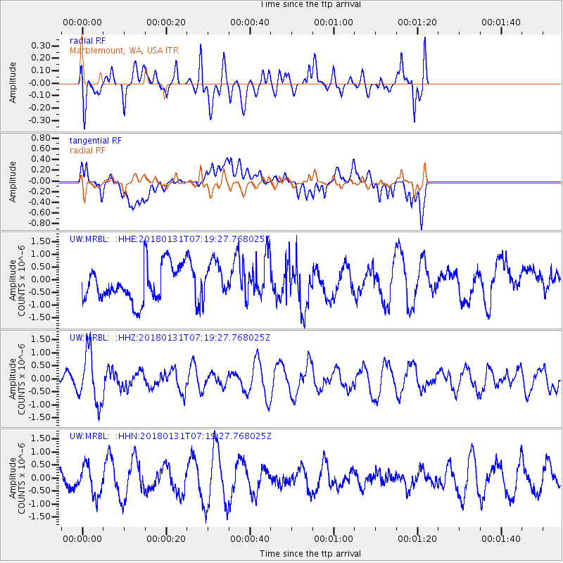
MRBL Marblemount, WA, USA - Earthquake Result Viewer
*The percent match for this event was below the threshold and hence no stack was calculated.
| Earthquake location: |
Hindu Kush Region, Afghanistan |
| Earthquake latitude/longitude: |
36.5/70.8 |
| Earthquake time(UTC): |
2018/01/31 (031) 07:07:00 GMT |
| Earthquake Depth: |
191 km |
| Earthquake Magnitude: |
6.1 Mww |
| Earthquake Catalog/Contributor: |
NEIC PDE/us |
|
| Network: |
UW Pacific Northwest Regional Seismic Network |
| Station: |
MRBL Marblemount, WA, USA |
| Lat/Lon: |
48.52 N/121.48 W |
| Elevation: |
75 m |
|
| Distance: |
94.6 deg |
| Az: |
8.169 deg |
| Baz: |
350.089 deg |
| Ray Param: |
$rayparam |
*The percent match for this event was below the threshold and hence was not used in the summary stack. |
|
| Radial Match: |
53.18844 % |
| Radial Bump: |
400 |
| Transverse Match: |
48.23702 % |
| Transverse Bump: |
400 |
| SOD ConfigId: |
13570011 |
| Insert Time: |
2019-04-29 16:53:15.676 +0000 |
| GWidth: |
2.5 |
| Max Bumps: |
400 |
| Tol: |
0.001 |
|
Signal To Noise
| Channel | StoN | STA | LTA |
| UW:MRBL: :HHZ:20180131T07:19:27.768025Z | 3.5155563 | 1.000514E-6 | 2.8459618E-7 |
| UW:MRBL: :HHN:20180131T07:19:27.768025Z | 2.3106117 | 5.835601E-7 | 2.5255653E-7 |
| UW:MRBL: :HHE:20180131T07:19:27.768025Z | 1.0113975 | 7.127254E-7 | 7.046936E-7 |
| Arrivals |
| Ps | |
| PpPs | |
| PsPs/PpSs | |


