You are here: Home > Network List > CI - Caltech Regional Seismic Network Stations List
> Station MPP McPhearson Peak > Earthquake Result Viewer
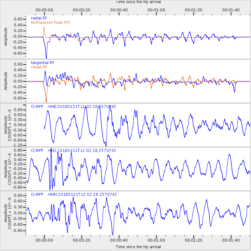
MPP McPhearson Peak - Earthquake Result Viewer
*The percent match for this event was below the threshold and hence no stack was calculated.
| Earthquake location: |
Eastern New Guinea Reg., P.N.G. |
| Earthquake latitude/longitude: |
-6.9/147.2 |
| Earthquake time(UTC): |
2018/01/31 (031) 11:49:39 GMT |
| Earthquake Depth: |
75 km |
| Earthquake Magnitude: |
5.6 Mww |
| Earthquake Catalog/Contributor: |
NEIC PDE/us |
|
| Network: |
CI Caltech Regional Seismic Network |
| Station: |
MPP McPhearson Peak |
| Lat/Lon: |
34.89 N/119.81 W |
| Elevation: |
1739 m |
|
| Distance: |
96.3 deg |
| Az: |
55.692 deg |
| Baz: |
266.001 deg |
| Ray Param: |
$rayparam |
*The percent match for this event was below the threshold and hence was not used in the summary stack. |
|
| Radial Match: |
69.74239 % |
| Radial Bump: |
400 |
| Transverse Match: |
40.485523 % |
| Transverse Bump: |
400 |
| SOD ConfigId: |
13570011 |
| Insert Time: |
2019-04-29 16:55:04.534 +0000 |
| GWidth: |
2.5 |
| Max Bumps: |
400 |
| Tol: |
0.001 |
|
Signal To Noise
| Channel | StoN | STA | LTA |
| CI:MPP: :HHZ:20180131T12:02:28.257974Z | 1.4895935 | 4.6833176E-7 | 3.1440237E-7 |
| CI:MPP: :HHN:20180131T12:02:28.257974Z | 0.83657986 | 2.304706E-7 | 2.7549146E-7 |
| CI:MPP: :HHE:20180131T12:02:28.257974Z | 1.6349797 | 8.295303E-7 | 5.073643E-7 |
| Arrivals |
| Ps | |
| PpPs | |
| PsPs/PpSs | |


