You are here: Home > Network List > TA - USArray Transportable Network (new EarthScope stations) Stations List
> Station H16K Elim, AK, USA > Earthquake Result Viewer
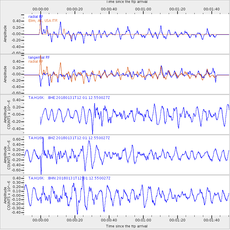
H16K Elim, AK, USA - Earthquake Result Viewer
*The percent match for this event was below the threshold and hence no stack was calculated.
| Earthquake location: |
Eastern New Guinea Reg., P.N.G. |
| Earthquake latitude/longitude: |
-6.9/147.2 |
| Earthquake time(UTC): |
2018/01/31 (031) 11:49:39 GMT |
| Earthquake Depth: |
75 km |
| Earthquake Magnitude: |
5.6 Mww |
| Earthquake Catalog/Contributor: |
NEIC PDE/us |
|
| Network: |
TA USArray Transportable Network (new EarthScope stations) |
| Station: |
H16K Elim, AK, USA |
| Lat/Lon: |
64.64 N/162.24 W |
| Elevation: |
216 m |
|
| Distance: |
80.6 deg |
| Az: |
19.699 deg |
| Baz: |
230.985 deg |
| Ray Param: |
$rayparam |
*The percent match for this event was below the threshold and hence was not used in the summary stack. |
|
| Radial Match: |
61.918766 % |
| Radial Bump: |
400 |
| Transverse Match: |
54.573704 % |
| Transverse Bump: |
400 |
| SOD ConfigId: |
13570011 |
| Insert Time: |
2019-04-29 16:57:20.390 +0000 |
| GWidth: |
2.5 |
| Max Bumps: |
400 |
| Tol: |
0.001 |
|
Signal To Noise
| Channel | StoN | STA | LTA |
| TA:H16K: :BHZ:20180131T12:01:12.550027Z | 1.8999388 | 2.658465E-7 | 1.3992371E-7 |
| TA:H16K: :BHN:20180131T12:01:12.550027Z | 0.38142818 | 8.77837E-8 | 2.3014476E-7 |
| TA:H16K: :BHE:20180131T12:01:12.550027Z | 1.5691106 | 1.9338651E-7 | 1.2324594E-7 |
| Arrivals |
| Ps | |
| PpPs | |
| PsPs/PpSs | |


