You are here: Home > Network List > TA - USArray Transportable Network (new EarthScope stations) Stations List
> Station V14A Boquillas Ranch, Navajo Nation, Peach Springs, AZ, > Earthquake Result Viewer
V14A Boquillas Ranch, Navajo Nation, Peach Springs, AZ, - Earthquake Result Viewer
| Earthquake location: |
Kuril Islands |
| Earthquake latitude/longitude: |
46.4/153.2 |
| Earthquake time(UTC): |
2008/03/03 (063) 09:31:02 GMT |
| Earthquake Depth: |
10 km |
| Earthquake Magnitude: |
6.2 MB, 6.5 MS, 6.5 MW, 6.5 MW |
| Earthquake Catalog/Contributor: |
WHDF/NEIC |
|
| Network: |
TA USArray Transportable Network (new EarthScope stations) |
| Station: |
V14A Boquillas Ranch, Navajo Nation, Peach Springs, AZ, |
| Lat/Lon: |
35.63 N/113.11 W |
| Elevation: |
1731 m |
|
| Distance: |
67.5 deg |
| Az: |
61.601 deg |
| Baz: |
311.649 deg |
| Ray Param: |
0.05689494 |
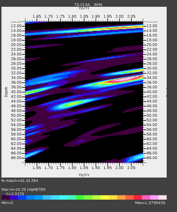
| Estimated Moho Depth: |
34.25 km |
| Estimated Crust Vp/Vs: |
2.02 |
| Assumed Crust Vp: |
6.276 km/s |
| Estimated Crust Vs: |
3.103 km/s |
| Estimated Crust Poisson's Ratio: |
0.34 |
|
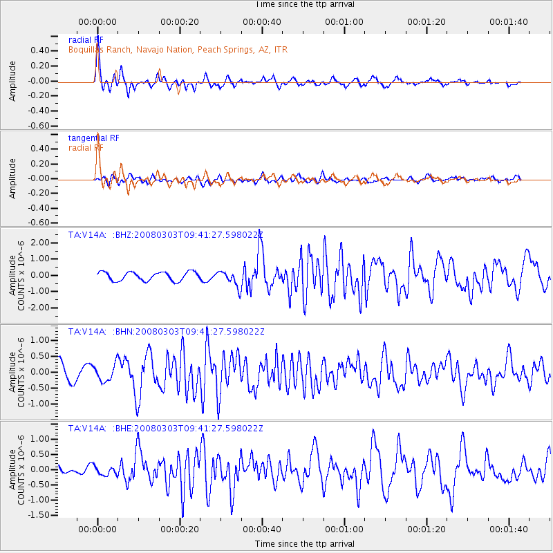
| Radial Match: |
81.81294 % |
| Radial Bump: |
360 |
| Transverse Match: |
65.565384 % |
| Transverse Bump: |
400 |
| SOD ConfigId: |
2564 |
| Insert Time: |
2010-03-06 08:34:39.813 +0000 |
| GWidth: |
2.5 |
| Max Bumps: |
400 |
| Tol: |
0.001 |
|
Signal To Noise
| Channel | StoN | STA | LTA |
| TA:V14A: :BHN:20080303T09:41:27.598022Z | 1.1151261 | 2.674601E-7 | 2.398474E-7 |
| TA:V14A: :BHE:20080303T09:41:27.598022Z | 1.1364962 | 1.2927698E-7 | 1.1375048E-7 |
| TA:V14A: :BHZ:20080303T09:41:27.598022Z | 1.9084142 | 5.114188E-7 | 2.6798102E-7 |
| Arrivals |
| Ps | 5.8 SECOND |
| PpPs | 16 SECOND |
| PsPs/PpSs | 22 SECOND |


