You are here: Home > Network List > TA - USArray Transportable Network (new EarthScope stations) Stations List
> Station V14A Boquillas Ranch, Navajo Nation, Peach Springs, AZ, > Earthquake Result Viewer
V14A Boquillas Ranch, Navajo Nation, Peach Springs, AZ, - Earthquake Result Viewer
| Earthquake location: |
Near Coast Of Peru |
| Earthquake latitude/longitude: |
-13.6/-76.6 |
| Earthquake time(UTC): |
2007/08/19 (231) 01:22:40 GMT |
| Earthquake Depth: |
26 km |
| Earthquake Magnitude: |
5.9 MB, 5.4 MS, 5.8 MW, 5.5 ML |
| Earthquake Catalog/Contributor: |
WHDF/NEIC |
|
| Network: |
TA USArray Transportable Network (new EarthScope stations) |
| Station: |
V14A Boquillas Ranch, Navajo Nation, Peach Springs, AZ, |
| Lat/Lon: |
35.63 N/113.11 W |
| Elevation: |
1731 m |
|
| Distance: |
59.9 deg |
| Az: |
325.964 deg |
| Baz: |
138.087 deg |
| Ray Param: |
0.061821185 |
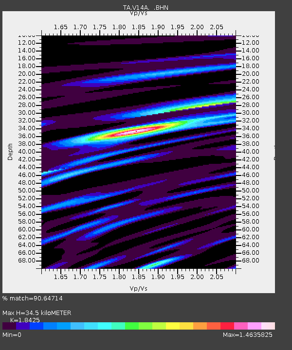
| Estimated Moho Depth: |
34.5 km |
| Estimated Crust Vp/Vs: |
1.84 |
| Assumed Crust Vp: |
6.276 km/s |
| Estimated Crust Vs: |
3.406 km/s |
| Estimated Crust Poisson's Ratio: |
0.29 |
|
| Radial Match: |
90.64714 % |
| Radial Bump: |
396 |
| Transverse Match: |
82.27256 % |
| Transverse Bump: |
360 |
| SOD ConfigId: |
2564 |
| Insert Time: |
2010-03-06 08:35:20.084 +0000 |
| GWidth: |
2.5 |
| Max Bumps: |
400 |
| Tol: |
0.001 |
|
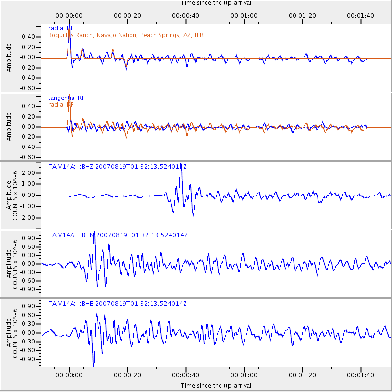
Signal To Noise
| Channel | StoN | STA | LTA |
| TA:V14A: :BHN:20070819T01:32:13.524014Z | 1.6356913 | 7.707837E-8 | 4.712281E-8 |
| TA:V14A: :BHE:20070819T01:32:13.524014Z | 1.5913328 | 1.0190612E-7 | 6.403822E-8 |
| TA:V14A: :BHZ:20070819T01:32:13.524014Z | 2.5906968 | 2.3507904E-7 | 9.07397E-8 |
| Arrivals |
| Ps | 4.8 SECOND |
| PpPs | 15 SECOND |
| PsPs/PpSs | 20 SECOND |


