You are here: Home > Network List > TA - USArray Transportable Network (new EarthScope stations) Stations List
> Station V14A Boquillas Ranch, Navajo Nation, Peach Springs, AZ, > Earthquake Result Viewer
V14A Boquillas Ranch, Navajo Nation, Peach Springs, AZ, - Earthquake Result Viewer
| Earthquake location: |
Near Coast Of Peru |
| Earthquake latitude/longitude: |
-14.3/-76.1 |
| Earthquake time(UTC): |
2007/08/16 (228) 05:16:56 GMT |
| Earthquake Depth: |
23 km |
| Earthquake Magnitude: |
5.8 MB, 6.1 MS, 6.3 MW, 6.2 ML |
| Earthquake Catalog/Contributor: |
WHDF/NEIC |
|
| Network: |
TA USArray Transportable Network (new EarthScope stations) |
| Station: |
V14A Boquillas Ranch, Navajo Nation, Peach Springs, AZ, |
| Lat/Lon: |
35.63 N/113.11 W |
| Elevation: |
1731 m |
|
| Distance: |
60.7 deg |
| Az: |
325.831 deg |
| Baz: |
138.055 deg |
| Ray Param: |
0.061298545 |
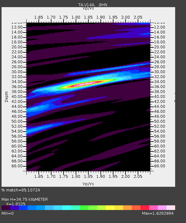
| Estimated Moho Depth: |
34.75 km |
| Estimated Crust Vp/Vs: |
1.83 |
| Assumed Crust Vp: |
6.276 km/s |
| Estimated Crust Vs: |
3.425 km/s |
| Estimated Crust Poisson's Ratio: |
0.29 |
|
| Radial Match: |
85.10724 % |
| Radial Bump: |
367 |
| Transverse Match: |
73.68307 % |
| Transverse Bump: |
400 |
| SOD ConfigId: |
2564 |
| Insert Time: |
2010-03-06 08:35:30.547 +0000 |
| GWidth: |
2.5 |
| Max Bumps: |
400 |
| Tol: |
0.001 |
|
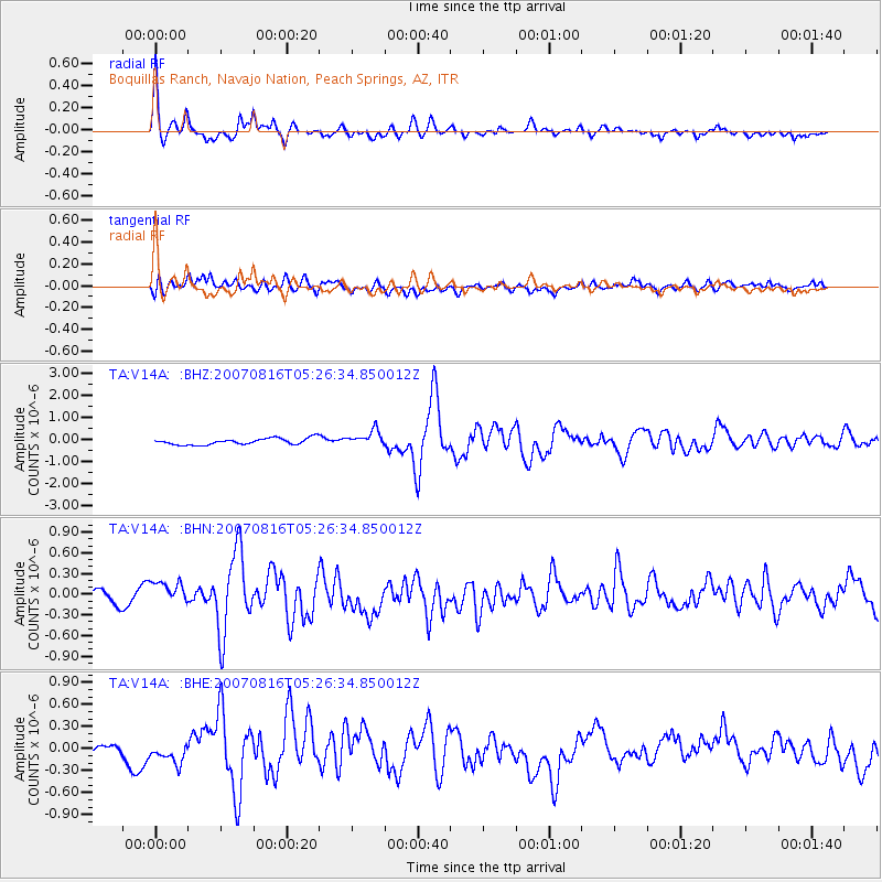
Signal To Noise
| Channel | StoN | STA | LTA |
| TA:V14A: :BHN:20070816T05:26:34.850012Z | 1.9254873 | 1.9428E-7 | 1.00899136E-7 |
| TA:V14A: :BHE:20070816T05:26:34.850012Z | 1.2562419 | 1.3431472E-7 | 1.06917874E-7 |
| TA:V14A: :BHZ:20070816T05:26:34.850012Z | 2.4560027 | 3.5309694E-7 | 1.4376896E-7 |
| Arrivals |
| Ps | 4.8 SECOND |
| PpPs | 15 SECOND |
| PsPs/PpSs | 20 SECOND |


