You are here: Home > Network List > TA - USArray Transportable Network (new EarthScope stations) Stations List
> Station V14A Boquillas Ranch, Navajo Nation, Peach Springs, AZ, > Earthquake Result Viewer
V14A Boquillas Ranch, Navajo Nation, Peach Springs, AZ, - Earthquake Result Viewer
| Earthquake location: |
Near Coast Of Peru |
| Earthquake latitude/longitude: |
-13.3/-76.5 |
| Earthquake time(UTC): |
2007/08/16 (228) 00:02:41 GMT |
| Earthquake Depth: |
40 km |
| Earthquake Magnitude: |
5.6 MB |
| Earthquake Catalog/Contributor: |
WHDF/NEIC |
|
| Network: |
TA USArray Transportable Network (new EarthScope stations) |
| Station: |
V14A Boquillas Ranch, Navajo Nation, Peach Springs, AZ, |
| Lat/Lon: |
35.63 N/113.11 W |
| Elevation: |
1731 m |
|
| Distance: |
59.7 deg |
| Az: |
325.755 deg |
| Baz: |
137.729 deg |
| Ray Param: |
0.06193711 |
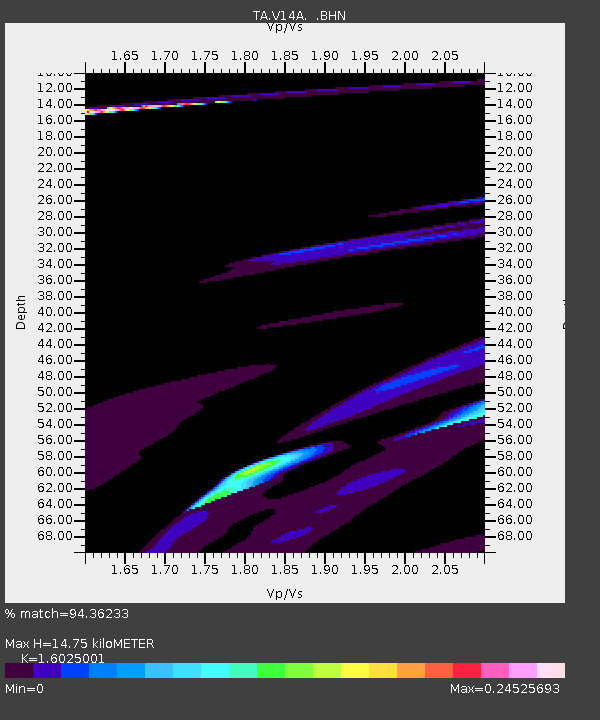
| Estimated Moho Depth: |
14.75 km |
| Estimated Crust Vp/Vs: |
1.60 |
| Assumed Crust Vp: |
6.276 km/s |
| Estimated Crust Vs: |
3.916 km/s |
| Estimated Crust Poisson's Ratio: |
0.18 |
|
| Radial Match: |
94.36233 % |
| Radial Bump: |
357 |
| Transverse Match: |
38.606766 % |
| Transverse Bump: |
243 |
| SOD ConfigId: |
2564 |
| Insert Time: |
2010-03-06 08:35:33.052 +0000 |
| GWidth: |
2.5 |
| Max Bumps: |
400 |
| Tol: |
0.001 |
|

Signal To Noise
| Channel | StoN | STA | LTA |
| TA:V14A: :BHN:20070816T00:12:11.025002Z | 1.5987583 | 1.7006876E-4 | 1.06375526E-4 |
| TA:V14A: :BHE:20070816T00:12:11.025002Z | 1.218592 | 1.2792576E-4 | 1.0497833E-4 |
| TA:V14A: :BHZ:20070816T00:12:11.025002Z | 0.5691076 | 1.1183728E-4 | 1.9651341E-4 |
| Arrivals |
| Ps | 1.5 SECOND |
| PpPs | 5.8 SECOND |
| PsPs/PpSs | 7.3 SECOND |


