You are here: Home > Network List > TA - USArray Transportable Network (new EarthScope stations) Stations List
> Station V14A Boquillas Ranch, Navajo Nation, Peach Springs, AZ, > Earthquake Result Viewer
V14A Boquillas Ranch, Navajo Nation, Peach Springs, AZ, - Earthquake Result Viewer
| Earthquake location: |
Jujuy Province, Argentina |
| Earthquake latitude/longitude: |
-22.2/-65.8 |
| Earthquake time(UTC): |
2007/07/21 (202) 15:34:52 GMT |
| Earthquake Depth: |
290 km |
| Earthquake Magnitude: |
5.8 MB, 6.4 MW, 6.3 MW |
| Earthquake Catalog/Contributor: |
WHDF/NEIC |
|
| Network: |
TA USArray Transportable Network (new EarthScope stations) |
| Station: |
V14A Boquillas Ranch, Navajo Nation, Peach Springs, AZ, |
| Lat/Lon: |
35.63 N/113.11 W |
| Elevation: |
1731 m |
|
| Distance: |
72.9 deg |
| Az: |
321.192 deg |
| Baz: |
134.5 deg |
| Ray Param: |
0.052549053 |
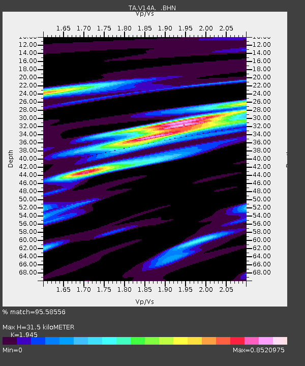
| Estimated Moho Depth: |
31.5 km |
| Estimated Crust Vp/Vs: |
1.95 |
| Assumed Crust Vp: |
6.276 km/s |
| Estimated Crust Vs: |
3.227 km/s |
| Estimated Crust Poisson's Ratio: |
0.32 |
|
| Radial Match: |
95.58556 % |
| Radial Bump: |
313 |
| Transverse Match: |
78.96056 % |
| Transverse Bump: |
400 |
| SOD ConfigId: |
2564 |
| Insert Time: |
2010-03-06 08:35:43.883 +0000 |
| GWidth: |
2.5 |
| Max Bumps: |
400 |
| Tol: |
0.001 |
|

Signal To Noise
| Channel | StoN | STA | LTA |
| TA:V14A: :BHN:20070721T15:45:19.250024Z | 3.585646 | 1.1051422E-7 | 3.082129E-8 |
| TA:V14A: :BHE:20070721T15:45:19.250024Z | 2.304274 | 8.5192895E-8 | 3.6971684E-8 |
| TA:V14A: :BHZ:20070721T15:45:19.250024Z | 5.663674 | 2.943603E-7 | 5.1973384E-8 |
| Arrivals |
| Ps | 4.9 SECOND |
| PpPs | 14 SECOND |
| PsPs/PpSs | 19 SECOND |


