You are here: Home > Network List > TA - USArray Transportable Network (new EarthScope stations) Stations List
> Station I23K Minto, Yukon-Koyukuk, AK, USA > Earthquake Result Viewer
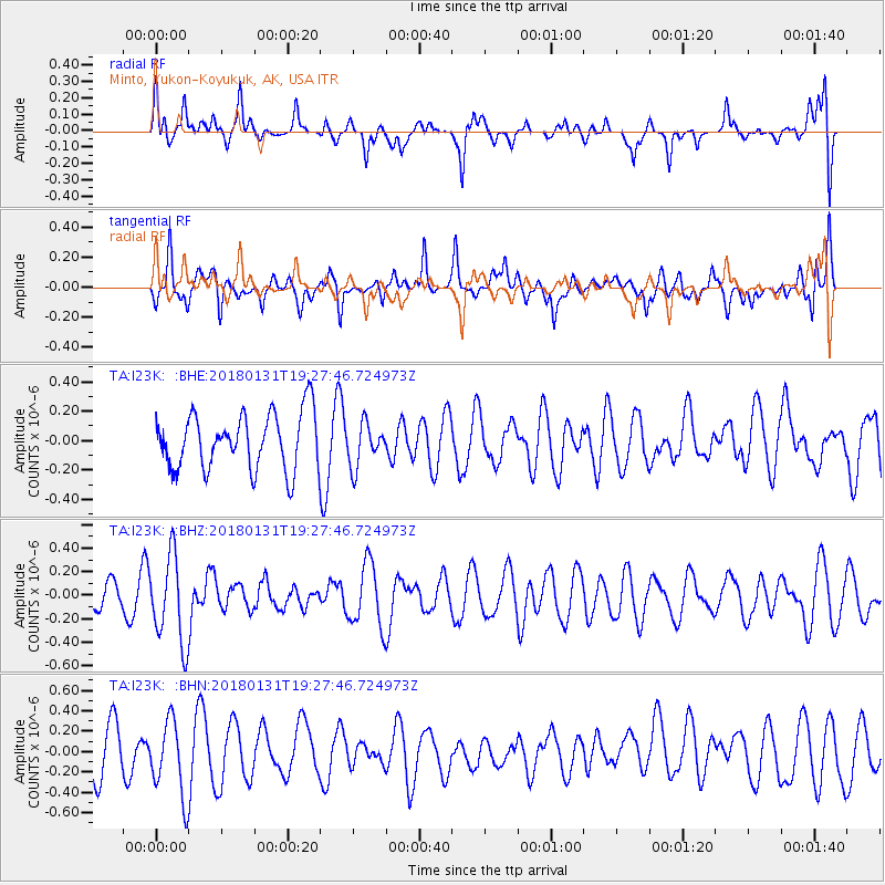
I23K Minto, Yukon-Koyukuk, AK, USA - Earthquake Result Viewer
*The percent match for this event was below the threshold and hence no stack was calculated.
| Earthquake location: |
Santa Cruz Islands Region |
| Earthquake latitude/longitude: |
-10.8/164.3 |
| Earthquake time(UTC): |
2018/01/31 (031) 19:15:51 GMT |
| Earthquake Depth: |
8.0 km |
| Earthquake Magnitude: |
5.5 Mww |
| Earthquake Catalog/Contributor: |
NEIC PDE/us |
|
| Network: |
TA USArray Transportable Network (new EarthScope stations) |
| Station: |
I23K Minto, Yukon-Koyukuk, AK, USA |
| Lat/Lon: |
65.15 N/149.36 W |
| Elevation: |
149 m |
|
| Distance: |
83.2 deg |
| Az: |
17.926 deg |
| Baz: |
225.692 deg |
| Ray Param: |
$rayparam |
*The percent match for this event was below the threshold and hence was not used in the summary stack. |
|
| Radial Match: |
48.047085 % |
| Radial Bump: |
377 |
| Transverse Match: |
59.302048 % |
| Transverse Bump: |
400 |
| SOD ConfigId: |
13570011 |
| Insert Time: |
2019-04-29 17:09:30.394 +0000 |
| GWidth: |
2.5 |
| Max Bumps: |
400 |
| Tol: |
0.001 |
|
Signal To Noise
| Channel | StoN | STA | LTA |
| TA:I23K: :BHZ:20180131T19:27:46.724973Z | 2.4061604 | 3.734937E-7 | 1.5522394E-7 |
| TA:I23K: :BHN:20180131T19:27:46.724973Z | 1.6419541 | 3.7642573E-7 | 2.2925474E-7 |
| TA:I23K: :BHE:20180131T19:27:46.724973Z | 0.7621205 | 1.44788E-7 | 1.8998045E-7 |
| Arrivals |
| Ps | |
| PpPs | |
| PsPs/PpSs | |


