You are here: Home > Network List > UW - Pacific Northwest Regional Seismic Network Stations List
> Station HOOD Mt Hood Meadows, OR CREST BB SMO > Earthquake Result Viewer
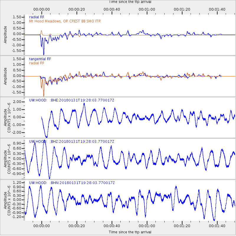
HOOD Mt Hood Meadows, OR CREST BB SMO - Earthquake Result Viewer
*The percent match for this event was below the threshold and hence no stack was calculated.
| Earthquake location: |
Santa Cruz Islands Region |
| Earthquake latitude/longitude: |
-10.8/164.3 |
| Earthquake time(UTC): |
2018/01/31 (031) 19:15:51 GMT |
| Earthquake Depth: |
8.0 km |
| Earthquake Magnitude: |
5.5 Mww |
| Earthquake Catalog/Contributor: |
NEIC PDE/us |
|
| Network: |
UW Pacific Northwest Regional Seismic Network |
| Station: |
HOOD Mt Hood Meadows, OR CREST BB SMO |
| Lat/Lon: |
45.32 N/121.65 W |
| Elevation: |
1520 m |
|
| Distance: |
86.6 deg |
| Az: |
42.801 deg |
| Baz: |
251.127 deg |
| Ray Param: |
$rayparam |
*The percent match for this event was below the threshold and hence was not used in the summary stack. |
|
| Radial Match: |
85.19444 % |
| Radial Bump: |
400 |
| Transverse Match: |
56.319534 % |
| Transverse Bump: |
400 |
| SOD ConfigId: |
13570011 |
| Insert Time: |
2019-04-29 17:10:15.774 +0000 |
| GWidth: |
2.5 |
| Max Bumps: |
400 |
| Tol: |
0.001 |
|
Signal To Noise
| Channel | StoN | STA | LTA |
| UW:HOOD: :BHZ:20180131T19:28:03.770017Z | 1.4338899 | 7.7697484E-7 | 5.418651E-7 |
| UW:HOOD: :BHN:20180131T19:28:03.770017Z | 1.3269651 | 6.925042E-7 | 5.2187073E-7 |
| UW:HOOD: :BHE:20180131T19:28:03.770017Z | 0.79705733 | 8.213806E-7 | 1.0305163E-6 |
| Arrivals |
| Ps | |
| PpPs | |
| PsPs/PpSs | |


