You are here: Home > Network List > TA - USArray Transportable Network (new EarthScope stations) Stations List
> Station V14A Boquillas Ranch, Navajo Nation, Peach Springs, AZ, > Earthquake Result Viewer
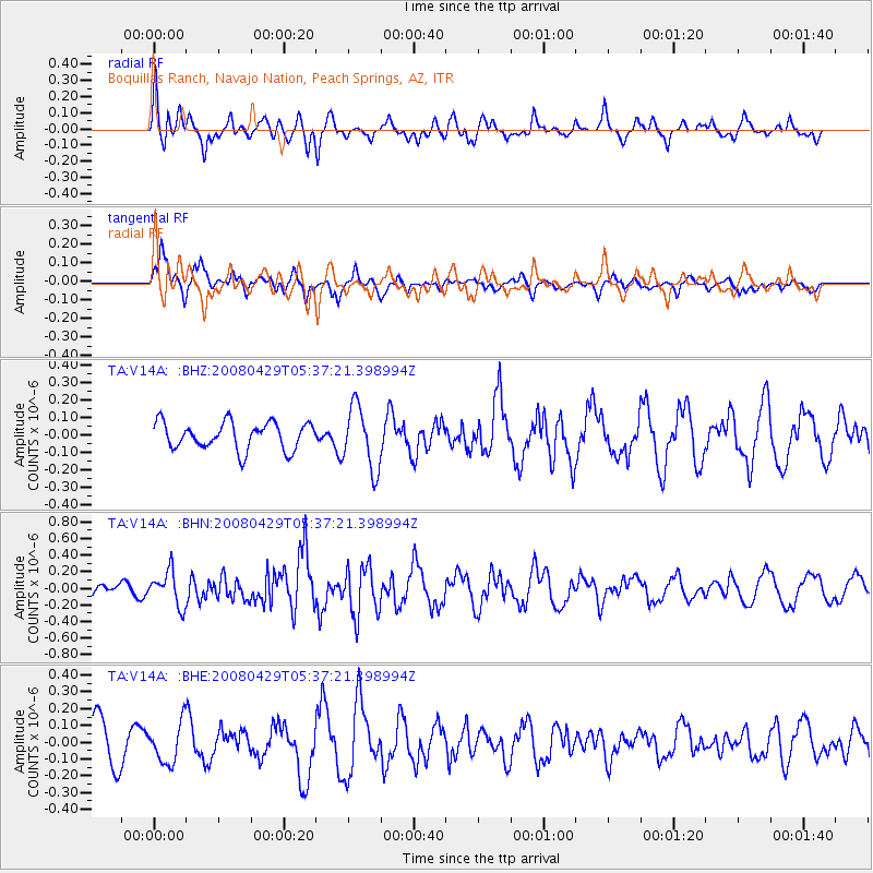
V14A Boquillas Ranch, Navajo Nation, Peach Springs, AZ, - Earthquake Result Viewer
*The percent match for this event was below the threshold and hence no stack was calculated.
| Earthquake location: |
Hokkaido, Japan Region |
| Earthquake latitude/longitude: |
41.5/142.0 |
| Earthquake time(UTC): |
2008/04/29 (120) 05:26:04 GMT |
| Earthquake Depth: |
47 km |
| Earthquake Magnitude: |
5.5 MB, 5.2 MS, 5.8 MW, 5.8 MW |
| Earthquake Catalog/Contributor: |
WHDF/NEIC |
|
| Network: |
TA USArray Transportable Network (new EarthScope stations) |
| Station: |
V14A Boquillas Ranch, Navajo Nation, Peach Springs, AZ, |
| Lat/Lon: |
35.63 N/113.11 W |
| Elevation: |
1731 m |
|
| Distance: |
77.0 deg |
| Az: |
53.915 deg |
| Baz: |
311.776 deg |
| Ray Param: |
$rayparam |
*The percent match for this event was below the threshold and hence was not used in the summary stack. |
|
| Radial Match: |
58.550415 % |
| Radial Bump: |
343 |
| Transverse Match: |
57.28137 % |
| Transverse Bump: |
364 |
| SOD ConfigId: |
2504 |
| Insert Time: |
2010-03-06 08:36:36.705 +0000 |
| GWidth: |
2.5 |
| Max Bumps: |
400 |
| Tol: |
0.001 |
|
Signal To Noise
| Channel | StoN | STA | LTA |
| TA:V14A: :BHN:20080429T05:37:21.398994Z | 2.2773273 | 2.0562273E-7 | 9.0291245E-8 |
| TA:V14A: :BHE:20080429T05:37:21.398994Z | 1.2066361 | 1.1717857E-7 | 9.711177E-8 |
| TA:V14A: :BHZ:20080429T05:37:21.398994Z | 2.32769 | 1.7927292E-7 | 7.7017525E-8 |
| Arrivals |
| Ps | |
| PpPs | |
| PsPs/PpSs | |


