You are here: Home > Network List > CN - Canadian National Seismograph Network Stations List
> Station INK INUVIK, NT > Earthquake Result Viewer
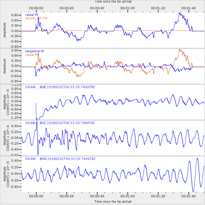
INK INUVIK, NT - Earthquake Result Viewer
*The percent match for this event was below the threshold and hence no stack was calculated.
| Earthquake location: |
Southern Molucca Sea |
| Earthquake latitude/longitude: |
-0.2/125.2 |
| Earthquake time(UTC): |
2018/02/02 (033) 00:20:42 GMT |
| Earthquake Depth: |
38 km |
| Earthquake Magnitude: |
5.5 Mww |
| Earthquake Catalog/Contributor: |
NEIC PDE/us |
|
| Network: |
CN Canadian National Seismograph Network |
| Station: |
INK INUVIK, NT |
| Lat/Lon: |
68.31 N/133.53 W |
| Elevation: |
44 m |
|
| Distance: |
94.4 deg |
| Az: |
21.449 deg |
| Baz: |
280.411 deg |
| Ray Param: |
$rayparam |
*The percent match for this event was below the threshold and hence was not used in the summary stack. |
|
| Radial Match: |
22.280254 % |
| Radial Bump: |
400 |
| Transverse Match: |
49.504513 % |
| Transverse Bump: |
400 |
| SOD ConfigId: |
13570011 |
| Insert Time: |
2019-04-29 17:18:26.080 +0000 |
| GWidth: |
2.5 |
| Max Bumps: |
400 |
| Tol: |
0.001 |
|
Signal To Noise
| Channel | StoN | STA | LTA |
| CN:INK: :BHZ:20180202T00:33:26.749978Z | 1.7656033 | 2.7403817E-7 | 1.5520938E-7 |
| CN:INK: :BHN:20180202T00:33:26.749978Z | 0.82525915 | 1.3205039E-7 | 1.6001081E-7 |
| CN:INK: :BHE:20180202T00:33:26.749978Z | 1.3336073 | 5.952975E-7 | 4.463814E-7 |
| Arrivals |
| Ps | |
| PpPs | |
| PsPs/PpSs | |


