You are here: Home > Network List > TA - USArray Transportable Network (new EarthScope stations) Stations List
> Station I30M Mount Dempster, Yukon, CAN > Earthquake Result Viewer
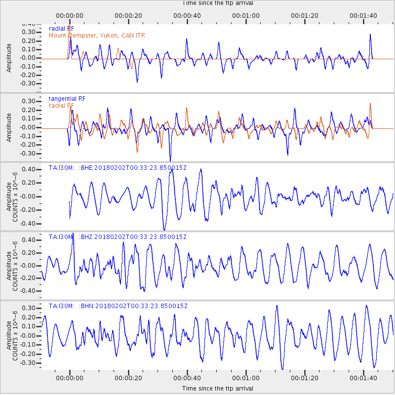
I30M Mount Dempster, Yukon, CAN - Earthquake Result Viewer
*The percent match for this event was below the threshold and hence no stack was calculated.
| Earthquake location: |
Southern Molucca Sea |
| Earthquake latitude/longitude: |
-0.2/125.2 |
| Earthquake time(UTC): |
2018/02/02 (033) 00:20:42 GMT |
| Earthquake Depth: |
38 km |
| Earthquake Magnitude: |
5.5 Mww |
| Earthquake Catalog/Contributor: |
NEIC PDE/us |
|
| Network: |
TA USArray Transportable Network (new EarthScope stations) |
| Station: |
I30M Mount Dempster, Yukon, CAN |
| Lat/Lon: |
65.22 N/136.38 W |
| Elevation: |
1399 m |
|
| Distance: |
93.8 deg |
| Az: |
24.693 deg |
| Baz: |
277.562 deg |
| Ray Param: |
$rayparam |
*The percent match for this event was below the threshold and hence was not used in the summary stack. |
|
| Radial Match: |
41.517246 % |
| Radial Bump: |
366 |
| Transverse Match: |
58.87128 % |
| Transverse Bump: |
377 |
| SOD ConfigId: |
13570011 |
| Insert Time: |
2019-04-29 17:20:22.936 +0000 |
| GWidth: |
2.5 |
| Max Bumps: |
400 |
| Tol: |
0.001 |
|
Signal To Noise
| Channel | StoN | STA | LTA |
| TA:I30M: :BHZ:20180202T00:33:23.850015Z | 2.2408042 | 2.0404E-7 | 9.10566E-8 |
| TA:I30M: :BHN:20180202T00:33:23.850015Z | 0.54632473 | 9.6979775E-8 | 1.7751306E-7 |
| TA:I30M: :BHE:20180202T00:33:23.850015Z | 2.496469 | 2.961517E-7 | 1.18628236E-7 |
| Arrivals |
| Ps | |
| PpPs | |
| PsPs/PpSs | |


