You are here: Home > Network List > UU - University of Utah Regional Network Stations List
> Station CCUT Cedar City, UT, USA > Earthquake Result Viewer
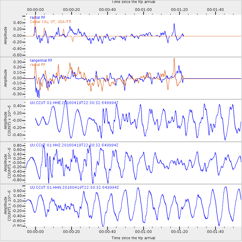
CCUT Cedar City, UT, USA - Earthquake Result Viewer
*The percent match for this event was below the threshold and hence no stack was calculated.
| Earthquake location: |
Near Coast Of Ecuador |
| Earthquake latitude/longitude: |
0.6/-80.1 |
| Earthquake time(UTC): |
2016/04/19 (110) 22:22:26 GMT |
| Earthquake Depth: |
15 km |
| Earthquake Magnitude: |
5.5 MB |
| Earthquake Catalog/Contributor: |
NEIC PDE/NEIC ALERT |
|
| Network: |
UU University of Utah Regional Network |
| Station: |
CCUT Cedar City, UT, USA |
| Lat/Lon: |
37.55 N/113.36 W |
| Elevation: |
2127 m |
|
| Distance: |
47.9 deg |
| Az: |
323.986 deg |
| Baz: |
132.289 deg |
| Ray Param: |
$rayparam |
*The percent match for this event was below the threshold and hence was not used in the summary stack. |
|
| Radial Match: |
57.339058 % |
| Radial Bump: |
400 |
| Transverse Match: |
65.688225 % |
| Transverse Bump: |
400 |
| SOD ConfigId: |
1475611 |
| Insert Time: |
2016-05-03 22:42:04.771 +0000 |
| GWidth: |
2.5 |
| Max Bumps: |
400 |
| Tol: |
0.001 |
|
Signal To Noise
| Channel | StoN | STA | LTA |
| UU:CCUT:01:HHZ:20160419T22:30:32.649994Z | 1.4804572 | 4.4883413E-7 | 3.0317264E-7 |
| UU:CCUT:01:HHN:20160419T22:30:32.649994Z | 1.7297869 | 3.3276916E-7 | 1.9237582E-7 |
| UU:CCUT:01:HHE:20160419T22:30:32.649994Z | 0.41396773 | 1.01895E-7 | 2.4614238E-7 |
| Arrivals |
| Ps | |
| PpPs | |
| PsPs/PpSs | |


