You are here: Home > Network List > TA - USArray Transportable Network (new EarthScope stations) Stations List
> Station V14A Boquillas Ranch, Navajo Nation, Peach Springs, AZ, > Earthquake Result Viewer
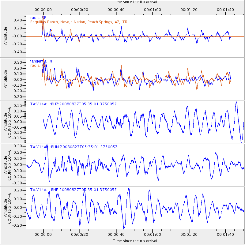
V14A Boquillas Ranch, Navajo Nation, Peach Springs, AZ, - Earthquake Result Viewer
*The percent match for this event was below the threshold and hence no stack was calculated.
| Earthquake location: |
Kuril Islands |
| Earthquake latitude/longitude: |
46.7/152.5 |
| Earthquake time(UTC): |
2008/08/27 (240) 05:24:41 GMT |
| Earthquake Depth: |
65 km |
| Earthquake Magnitude: |
5.5 MB, 5.4 MW, 5.3 MW |
| Earthquake Catalog/Contributor: |
WHDF/NEIC |
|
| Network: |
TA USArray Transportable Network (new EarthScope stations) |
| Station: |
V14A Boquillas Ranch, Navajo Nation, Peach Springs, AZ, |
| Lat/Lon: |
35.63 N/113.11 W |
| Elevation: |
1731 m |
|
| Distance: |
67.8 deg |
| Az: |
61.31 deg |
| Baz: |
312.198 deg |
| Ray Param: |
$rayparam |
*The percent match for this event was below the threshold and hence was not used in the summary stack. |
|
| Radial Match: |
54.537334 % |
| Radial Bump: |
400 |
| Transverse Match: |
52.929985 % |
| Transverse Bump: |
393 |
| SOD ConfigId: |
2504 |
| Insert Time: |
2010-03-06 08:37:23.406 +0000 |
| GWidth: |
2.5 |
| Max Bumps: |
400 |
| Tol: |
0.001 |
|
Signal To Noise
| Channel | StoN | STA | LTA |
| TA:V14A: :BHN:20080827T05:35:01.375005Z | 2.363787 | 1.7993295E-7 | 7.6120635E-8 |
| TA:V14A: :BHE:20080827T05:35:01.375005Z | 1.0348041 | 9.660881E-8 | 9.335952E-8 |
| TA:V14A: :BHZ:20080827T05:35:01.375005Z | 0.6267408 | 3.9543846E-8 | 6.309442E-8 |
| Arrivals |
| Ps | |
| PpPs | |
| PsPs/PpSs | |


