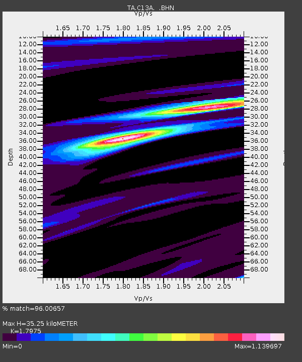
C13A Hot Springs, MT, USA - Earthquake Result Viewer
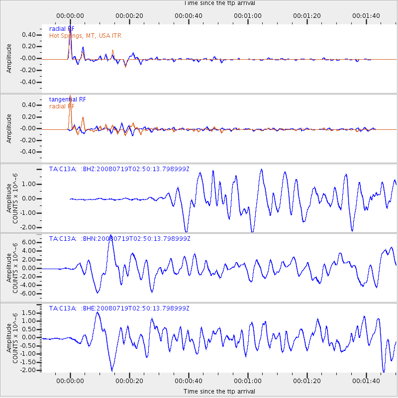
Earthquake location: Off East Coast Of Honshu, Japan
Earthquake latitude/longitude: 37.6/142.2
Earthquake time(UTC): 2008/07/19 (201) 02:39:28 GMT
Earthquake Depth: 22 km
Earthquake Magnitude: 6.2 MB, 7.0 MS, 7.0 MW, 6.9 MW
Earthquake Catalog/Contributor: WHDF/NEIC
Network: TA USArray Transportable Network (new EarthScope stations)
Station: C13A Hot Springs, MT, USA
Lat/Lon: 47.68 N/114.57 W
Elevation: 976 m
Distance: 71.1 deg
Az: 44.069 deg
Baz: 305.111 deg
Ray Param: 0.054547653
Estimated Moho Depth: 35.25 km
Estimated Crust Vp/Vs: 1.80
Assumed Crust Vp: 6.622 km/s
Estimated Crust Vs: 3.684 km/s
Estimated Crust Poisson's Ratio: 0.28
Radial Match: 96.00657 %
Radial Bump: 240
Transverse Match: 86.51617 %
Transverse Bump: 400
SOD ConfigId: 2504
Insert Time: 2010-03-06 08:37:34.374 +0000
GWidth: 2.5
Max Bumps: 400
Tol: 0.001

Signal To Noise

ChannelStoNSTALTA
TA:C13A: :BHN:20080719T02:50:13.798999Z12.1438546.589698E-75.4263644E-8
TA:C13A: :BHE:20080719T02:50:13.798999Z3.33272461.5932136E-74.780514E-8
TA:C13A: :BHZ:20080719T02:50:13.798999Z6.86064532.223338E-73.2407126E-8
Arrivals
Ps4.4 SECOND
PpPs14 SECOND
PsPs/PpSs19 SECOND