You are here: Home > Network List > AG - Arkansas Seismic Network Stations List
> Station HHAR Hobbs,AR > Earthquake Result Viewer
HHAR Hobbs,AR - Earthquake Result Viewer
| Earthquake location: |
Near Coast Of Ecuador |
| Earthquake latitude/longitude: |
0.6/-80.3 |
| Earthquake time(UTC): |
2016/04/20 (111) 08:33:48 GMT |
| Earthquake Depth: |
16 km |
| Earthquake Magnitude: |
6.1 MO |
| Earthquake Catalog/Contributor: |
NEIC PDE/NEIC ALERT |
|
| Network: |
AG Arkansas Seismic Network |
| Station: |
HHAR Hobbs,AR |
| Lat/Lon: |
36.28 N/93.94 W |
| Elevation: |
421 m |
|
| Distance: |
37.7 deg |
| Az: |
341.792 deg |
| Baz: |
157.25 deg |
| Ray Param: |
0.07597485 |
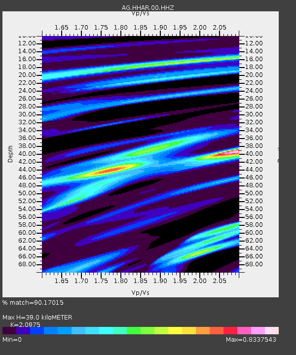
| Estimated Moho Depth: |
39.0 km |
| Estimated Crust Vp/Vs: |
2.10 |
| Assumed Crust Vp: |
6.53 km/s |
| Estimated Crust Vs: |
3.113 km/s |
| Estimated Crust Poisson's Ratio: |
0.35 |
|
| Radial Match: |
90.17015 % |
| Radial Bump: |
326 |
| Transverse Match: |
61.54516 % |
| Transverse Bump: |
400 |
| SOD ConfigId: |
1475611 |
| Insert Time: |
2016-05-04 08:34:01.936 +0000 |
| GWidth: |
2.5 |
| Max Bumps: |
400 |
| Tol: |
0.001 |
|

Signal To Noise
| Channel | StoN | STA | LTA |
| AG:HHAR:00:HHZ:20160420T08:40:31.859985Z | 3.7720995 | 4.296572E-7 | 1.13904E-7 |
| AG:HHAR:00:HHN:20160420T08:40:31.859985Z | 4.023526 | 2.9356676E-7 | 7.296255E-8 |
| AG:HHAR:00:HHE:20160420T08:40:31.859985Z | 1.7921633 | 4.886046E-7 | 2.7263397E-7 |
| Arrivals |
| Ps | 7.0 SECOND |
| PpPs | 17 SECOND |
| PsPs/PpSs | 24 SECOND |


