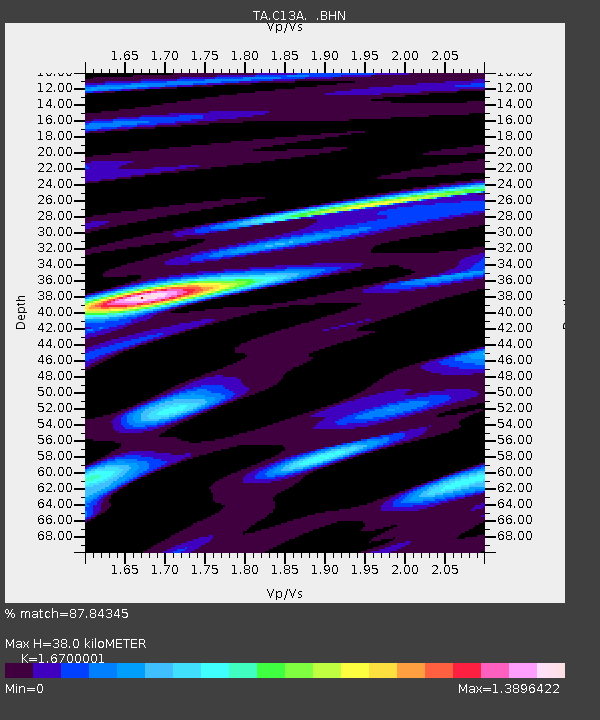
C13A Hot Springs, MT, USA - Earthquake Result Viewer
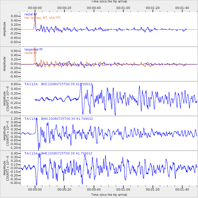
Earthquake location: Rat Islands, Aleutian Islands
Earthquake latitude/longitude: 51.3/179.0
Earthquake time(UTC): 2008/07/25 (207) 00:29:22 GMT
Earthquake Depth: 21 km
Earthquake Magnitude: 5.7 MB, 5.5 MS, 5.9 MW, 5.9 MW
Earthquake Catalog/Contributor: WHDF/NEIC
Network: TA USArray Transportable Network (new EarthScope stations)
Station: C13A Hot Springs, MT, USA
Lat/Lon: 47.68 N/114.57 W
Elevation: 976 m
Distance: 42.0 deg
Az: 67.796 deg
Baz: 300.623 deg
Ray Param: 0.07340773
Estimated Moho Depth: 38.0 km
Estimated Crust Vp/Vs: 1.67
Assumed Crust Vp: 6.622 km/s
Estimated Crust Vs: 3.965 km/s
Estimated Crust Poisson's Ratio: 0.22
Radial Match: 87.84345 %
Radial Bump: 400
Transverse Match: 76.95344 %
Transverse Bump: 400
SOD ConfigId: 2504
Insert Time: 2010-03-06 08:37:41.655 +0000
GWidth: 2.5
Max Bumps: 400
Tol: 0.001

Signal To Noise

ChannelStoNSTALTA
TA:C13A: :BHN:20080725T00:36:41.79901Z7.41059546.952987E-79.3824944E-8
TA:C13A: :BHE:20080725T00:36:41.79901Z4.60169462.4438185E-75.3106923E-8
TA:C13A: :BHZ:20080725T00:36:41.79901Z6.56184633.4909587E-75.320086E-8
Arrivals
Ps4.2 SECOND
PpPs14 SECOND
PsPs/PpSs18 SECOND