You are here: Home > Network List > TA - USArray Transportable Network (new EarthScope stations) Stations List
> Station D23K Nanushuk River, AK USA > Earthquake Result Viewer
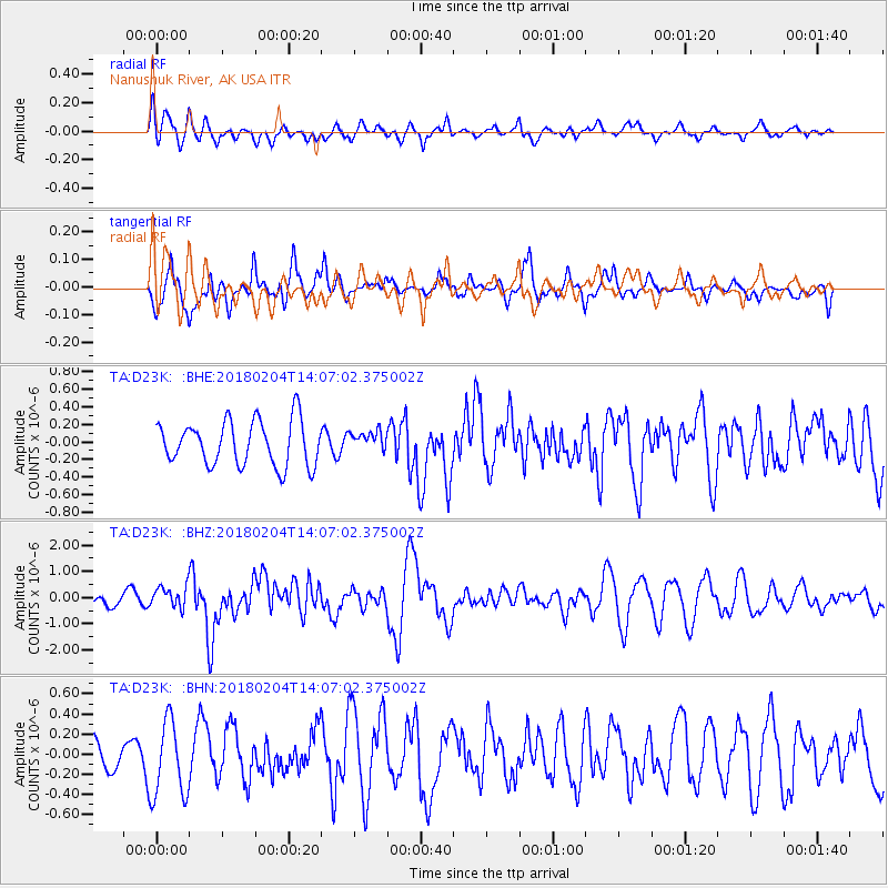
D23K Nanushuk River, AK USA - Earthquake Result Viewer
*The percent match for this event was below the threshold and hence no stack was calculated.
| Earthquake location: |
Taiwan |
| Earthquake latitude/longitude: |
24.1/121.7 |
| Earthquake time(UTC): |
2018/02/04 (035) 13:56:41 GMT |
| Earthquake Depth: |
7.8 km |
| Earthquake Magnitude: |
6.1 Mww |
| Earthquake Catalog/Contributor: |
NEIC PDE/us |
|
| Network: |
TA USArray Transportable Network (new EarthScope stations) |
| Station: |
D23K Nanushuk River, AK USA |
| Lat/Lon: |
68.97 N/150.68 W |
| Elevation: |
406 m |
|
| Distance: |
66.9 deg |
| Az: |
23.088 deg |
| Baz: |
276.983 deg |
| Ray Param: |
$rayparam |
*The percent match for this event was below the threshold and hence was not used in the summary stack. |
|
| Radial Match: |
70.766426 % |
| Radial Bump: |
400 |
| Transverse Match: |
76.193306 % |
| Transverse Bump: |
400 |
| SOD ConfigId: |
13570011 |
| Insert Time: |
2019-04-29 17:26:29.647 +0000 |
| GWidth: |
2.5 |
| Max Bumps: |
400 |
| Tol: |
0.001 |
|
Signal To Noise
| Channel | StoN | STA | LTA |
| TA:D23K: :BHZ:20180204T14:07:02.375002Z | 1.3388816 | 4.143567E-7 | 3.094797E-7 |
| TA:D23K: :BHN:20180204T14:07:02.375002Z | 2.551765 | 3.8192755E-7 | 1.4967192E-7 |
| TA:D23K: :BHE:20180204T14:07:02.375002Z | 0.47958604 | 1.2111579E-7 | 2.5254235E-7 |
| Arrivals |
| Ps | |
| PpPs | |
| PsPs/PpSs | |


