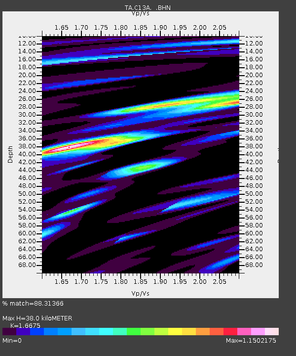
C13A Hot Springs, MT, USA - Earthquake Result Viewer
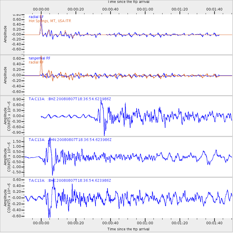
Earthquake location: Andreanof Islands, Aleutian Is.
Earthquake latitude/longitude: 52.2/-175.7
Earthquake time(UTC): 2008/08/07 (220) 18:30:03 GMT
Earthquake Depth: 12 km
Earthquake Magnitude: 5.6 MB, 5.5 MS, 5.8 MW, 5.8 MW
Earthquake Catalog/Contributor: WHDF/NEIC
Network: TA USArray Transportable Network (new EarthScope stations)
Station: C13A Hot Springs, MT, USA
Lat/Lon: 47.68 N/114.57 W
Elevation: 976 m
Distance: 38.5 deg
Az: 71.644 deg
Baz: 300.156 deg
Ray Param: 0.07549318
Estimated Moho Depth: 38.0 km
Estimated Crust Vp/Vs: 1.67
Assumed Crust Vp: 6.622 km/s
Estimated Crust Vs: 3.971 km/s
Estimated Crust Poisson's Ratio: 0.22
Radial Match: 88.31366 %
Radial Bump: 400
Transverse Match: 68.22643 %
Transverse Bump: 400
SOD ConfigId: 2504
Insert Time: 2010-03-06 08:37:45.586 +0000
GWidth: 2.5
Max Bumps: 400
Tol: 0.001

Signal To Noise

ChannelStoNSTALTA
TA:C13A: :BHN:20080807T18:36:54.623986Z11.4908356.018379E-75.2375473E-8
TA:C13A: :BHE:20080807T18:36:54.623986Z5.80462031.9820077E-73.4145344E-8
TA:C13A: :BHZ:20080807T18:36:54.623986Z5.7389732.8850954E-75.027198E-8
Arrivals
Ps4.2 SECOND
PpPs14 SECOND
PsPs/PpSs18 SECOND