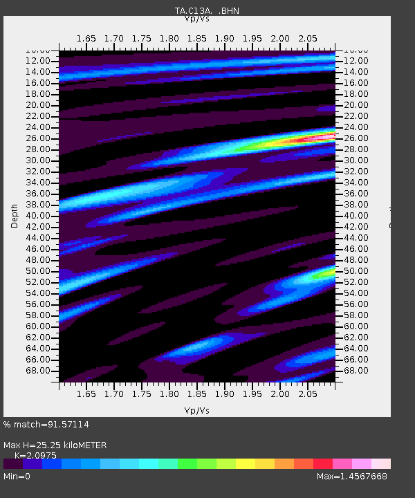
C13A Hot Springs, MT, USA - Earthquake Result Viewer
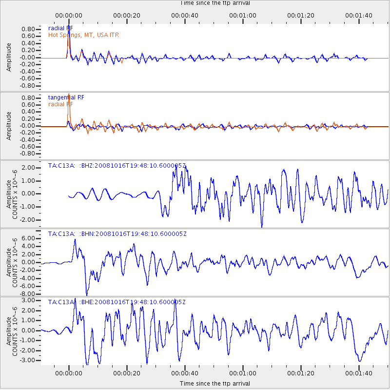
Earthquake location: Near Coast Of Chiapas, Mexico
Earthquake latitude/longitude: 14.4/-92.4
Earthquake time(UTC): 2008/10/16 (290) 19:41:25 GMT
Earthquake Depth: 24 km
Earthquake Magnitude: 6.1 MB, 6.6 MS, 6.7 MW, 6.6 MW
Earthquake Catalog/Contributor: WHDF/NEIC
Network: TA USArray Transportable Network (new EarthScope stations)
Station: C13A Hot Springs, MT, USA
Lat/Lon: 47.68 N/114.57 W
Elevation: 976 m
Distance: 37.9 deg
Az: 335.456 deg
Baz: 143.446 deg
Ray Param: 0.07580908
Estimated Moho Depth: 25.25 km
Estimated Crust Vp/Vs: 2.10
Assumed Crust Vp: 6.622 km/s
Estimated Crust Vs: 3.157 km/s
Estimated Crust Poisson's Ratio: 0.35
Radial Match: 91.57114 %
Radial Bump: 400
Transverse Match: 72.16293 %
Transverse Bump: 400
SOD ConfigId: 2556
Insert Time: 2010-03-06 08:37:51.793 +0000
GWidth: 2.5
Max Bumps: 400
Tol: 0.001

Signal To Noise

ChannelStoNSTALTA
TA:C13A: :BHN:20081016T19:48:10.600005Z11.7916472.589156E-62.1957544E-7
TA:C13A: :BHE:20081016T19:48:10.600005Z5.71835661.4102169E-62.4661225E-7
TA:C13A: :BHZ:20081016T19:48:10.600005Z4.3232749.408936E-72.176345E-7
Arrivals
Ps4.5 SECOND
PpPs11 SECOND
PsPs/PpSs16 SECOND