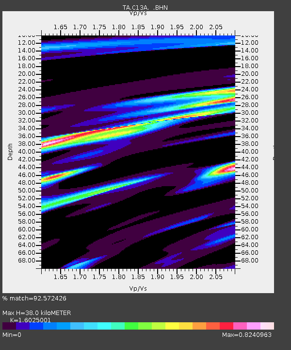
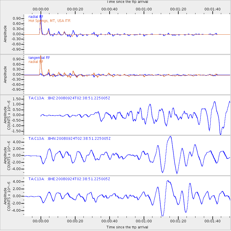
C13A Hot Springs, MT, USA - Earthquake Result Viewer

Earthquake location: Off Coast Of Jalisco, Mexico
Earthquake latitude/longitude: 17.6/-105.5
Earthquake time(UTC): 2008/09/24 (268) 02:33:05 GMT
Earthquake Depth: 10 km
Earthquake Magnitude: 5.7 MB, 6.2 MS, 6.4 MW, 6.4 MW
Earthquake Catalog/Contributor: WHDF/NEIC
Network: TA USArray Transportable Network (new EarthScope stations)
Station: C13A Hot Springs, MT, USA
Lat/Lon: 47.68 N/114.57 W
Elevation: 976 m
Distance: 30.9 deg
Az: 348.025 deg
Baz: 162.971 deg
Ray Param: 0.07920982
Estimated Moho Depth: 38.0 km
Estimated Crust Vp/Vs: 1.60
Assumed Crust Vp: 6.622 km/s
Estimated Crust Vs: 4.132 km/s
Estimated Crust Poisson's Ratio: 0.18
Radial Match: 92.572426 %
Radial Bump: 254
Transverse Match: 54.676056 %
Transverse Bump: 400
SOD ConfigId: 2560
Insert Time: 2010-03-06 08:38:09.996 +0000
GWidth: 2.5
Max Bumps: 400
Tol: 0.001

Signal To Noise

ChannelStoNSTALTA
TA:C13A: :BHN:20080924T02:38:51.225005Z17.6134191.3883894E-67.8825664E-8
TA:C13A: :BHE:20080924T02:38:51.225005Z20.5154139.568804E-74.6642022E-8
TA:C13A: :BHZ:20080924T02:38:51.225005Z3.72882492.1646076E-75.8050666E-8
Arrivals
Ps3.8 SECOND
PpPs14 SECOND
PsPs/PpSs17 SECOND