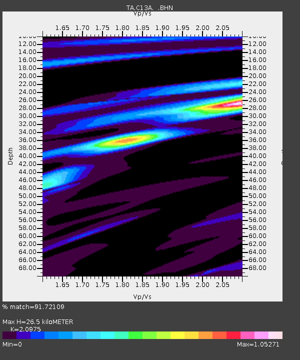
C13A Hot Springs, MT, USA - Earthquake Result Viewer
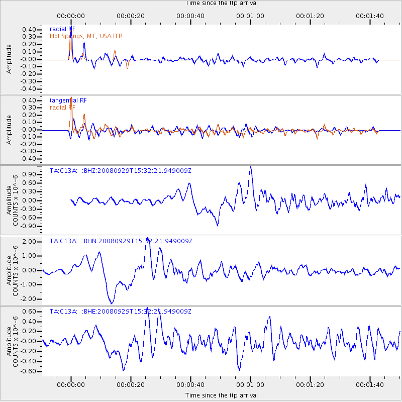
Earthquake location: Kermadec Islands, New Zealand
Earthquake latitude/longitude: -29.8/-177.7
Earthquake time(UTC): 2008/09/29 (273) 15:19:31 GMT
Earthquake Depth: 36 km
Earthquake Magnitude: 6.5 MB, 6.7 MS, 7.0 MW, 7.0 MW
Earthquake Catalog/Contributor: WHDF/NEIC
Network: TA USArray Transportable Network (new EarthScope stations)
Station: C13A Hot Springs, MT, USA
Lat/Lon: 47.68 N/114.57 W
Elevation: 976 m
Distance: 95.6 deg
Az: 37.273 deg
Baz: 231.198 deg
Ray Param: 0.040712915
Estimated Moho Depth: 26.5 km
Estimated Crust Vp/Vs: 2.10
Assumed Crust Vp: 6.622 km/s
Estimated Crust Vs: 3.157 km/s
Estimated Crust Poisson's Ratio: 0.35
Radial Match: 91.72109 %
Radial Bump: 400
Transverse Match: 66.38696 %
Transverse Bump: 400
SOD ConfigId: 2560
Insert Time: 2010-03-06 08:38:12.341 +0000
GWidth: 2.5
Max Bumps: 400
Tol: 0.001

Signal To Noise

ChannelStoNSTALTA
TA:C13A: :BHN:20080929T15:32:21.949009Z6.33683355.856478E-79.241963E-8
TA:C13A: :BHE:20080929T15:32:21.949009Z0.84202579.231065E-81.09629255E-7
TA:C13A: :BHZ:20080929T15:32:21.949009Z1.78935431.2275716E-76.8604166E-8
Arrivals
Ps4.5 SECOND
PpPs12 SECOND
PsPs/PpSs17 SECOND