You are here: Home > Network List > TA - USArray Transportable Network (new EarthScope stations) Stations List
> Station C13A Hot Springs, MT, USA > Earthquake Result Viewer
C13A Hot Springs, MT, USA - Earthquake Result Viewer
| Earthquake location: |
Svalbard Region |
| Earthquake latitude/longitude: |
77.1/18.6 |
| Earthquake time(UTC): |
2008/02/21 (052) 02:46:17 GMT |
| Earthquake Depth: |
10 km |
| Earthquake Magnitude: |
5.7 MB, 5.9 MS, 6.1 MW, 6.0 MW |
| Earthquake Catalog/Contributor: |
WHDF/NEIC |
|
| Network: |
TA USArray Transportable Network (new EarthScope stations) |
| Station: |
C13A Hot Springs, MT, USA |
| Lat/Lon: |
47.68 N/114.57 W |
| Elevation: |
976 m |
|
| Distance: |
52.1 deg |
| Az: |
321.333 deg |
| Baz: |
12.008 deg |
| Ray Param: |
0.06697436 |
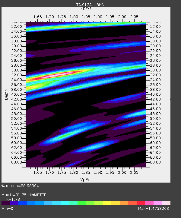
| Estimated Moho Depth: |
31.75 km |
| Estimated Crust Vp/Vs: |
1.73 |
| Assumed Crust Vp: |
6.622 km/s |
| Estimated Crust Vs: |
3.828 km/s |
| Estimated Crust Poisson's Ratio: |
0.25 |
|
| Radial Match: |
88.98394 % |
| Radial Bump: |
364 |
| Transverse Match: |
70.06206 % |
| Transverse Bump: |
400 |
| SOD ConfigId: |
2564 |
| Insert Time: |
2010-03-06 08:38:14.223 +0000 |
| GWidth: |
2.5 |
| Max Bumps: |
400 |
| Tol: |
0.001 |
|
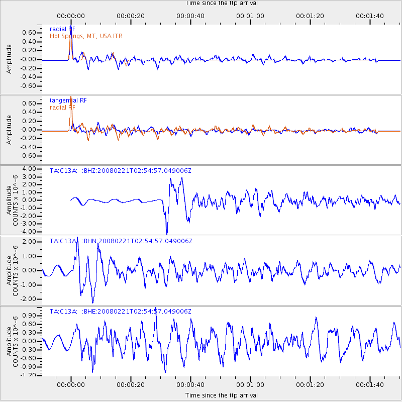
Signal To Noise
| Channel | StoN | STA | LTA |
| TA:C13A: :BHN:20080221T02:54:57.049006Z | 5.222659 | 1.0805383E-6 | 2.0689427E-7 |
| TA:C13A: :BHE:20080221T02:54:57.049006Z | 1.5220054 | 3.4225462E-7 | 2.2487083E-7 |
| TA:C13A: :BHZ:20080221T02:54:57.049006Z | 8.514837 | 1.8410026E-6 | 2.1621112E-7 |
| Arrivals |
| Ps | 3.7 SECOND |
| PpPs | 12 SECOND |
| PsPs/PpSs | 16 SECOND |


