You are here: Home > Network List > TA - USArray Transportable Network (new EarthScope stations) Stations List
> Station C13A Hot Springs, MT, USA > Earthquake Result Viewer
C13A Hot Springs, MT, USA - Earthquake Result Viewer
| Earthquake location: |
Santa Cruz Islands Region |
| Earthquake latitude/longitude: |
-11.0/164.5 |
| Earthquake time(UTC): |
2008/07/19 (201) 09:27:01 GMT |
| Earthquake Depth: |
11 km |
| Earthquake Magnitude: |
6.1 MB, 6.4 MS, 6.6 MW, 6.6 MW |
| Earthquake Catalog/Contributor: |
WHDF/NEIC |
|
| Network: |
TA USArray Transportable Network (new EarthScope stations) |
| Station: |
C13A Hot Springs, MT, USA |
| Lat/Lon: |
47.68 N/114.57 W |
| Elevation: |
976 m |
|
| Distance: |
92.0 deg |
| Az: |
41.892 deg |
| Baz: |
255.95 deg |
| Ray Param: |
0.041517094 |
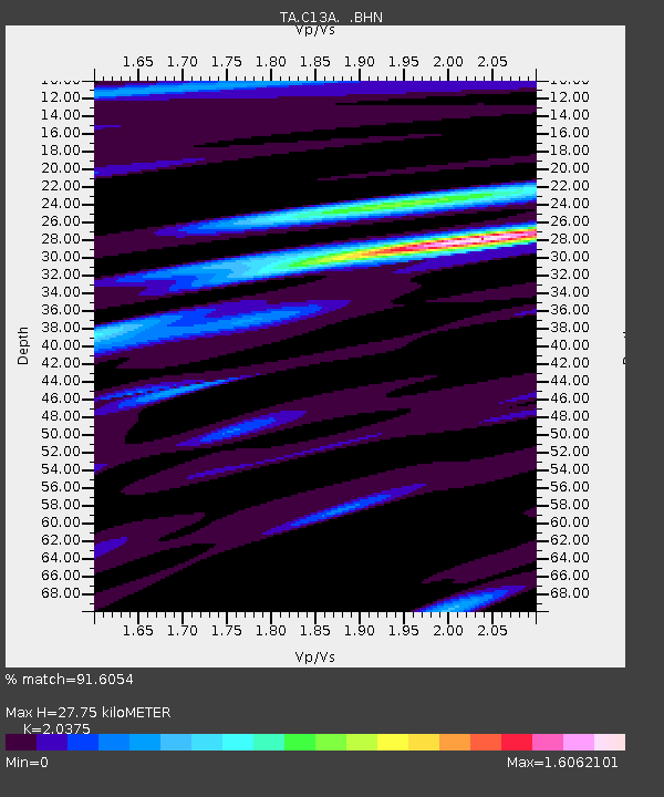
| Estimated Moho Depth: |
27.75 km |
| Estimated Crust Vp/Vs: |
2.04 |
| Assumed Crust Vp: |
6.622 km/s |
| Estimated Crust Vs: |
3.25 km/s |
| Estimated Crust Poisson's Ratio: |
0.34 |
|
| Radial Match: |
91.6054 % |
| Radial Bump: |
400 |
| Transverse Match: |
76.19956 % |
| Transverse Bump: |
400 |
| SOD ConfigId: |
2658 |
| Insert Time: |
2010-03-06 08:38:16.834 +0000 |
| GWidth: |
2.5 |
| Max Bumps: |
400 |
| Tol: |
0.001 |
|
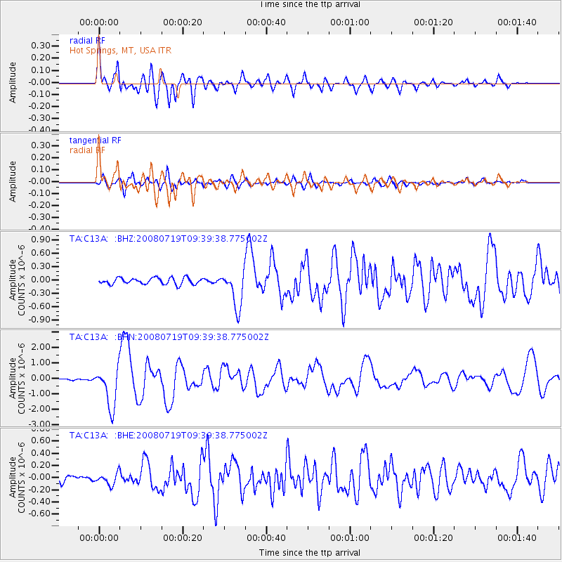
Signal To Noise
| Channel | StoN | STA | LTA |
| TA:C13A: :BHN:20080719T09:39:38.775002Z | 22.42171 | 1.3378267E-6 | 5.9666576E-8 |
| TA:C13A: :BHE:20080719T09:39:38.775002Z | 1.5245341 | 9.709347E-8 | 6.36873E-8 |
| TA:C13A: :BHZ:20080719T09:39:38.775002Z | 6.0226574 | 4.281182E-7 | 7.108461E-8 |
| Arrivals |
| Ps | 4.4 SECOND |
| PpPs | 12 SECOND |
| PsPs/PpSs | 17 SECOND |


