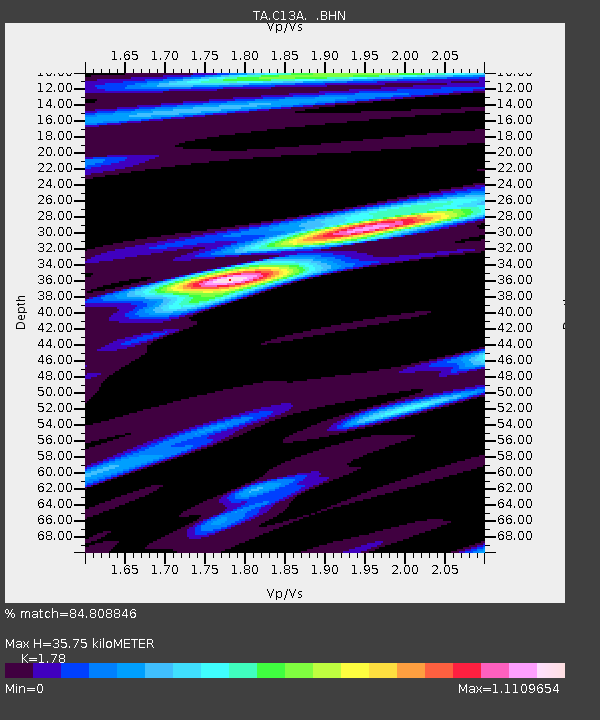
C13A Hot Springs, MT, USA - Earthquake Result Viewer
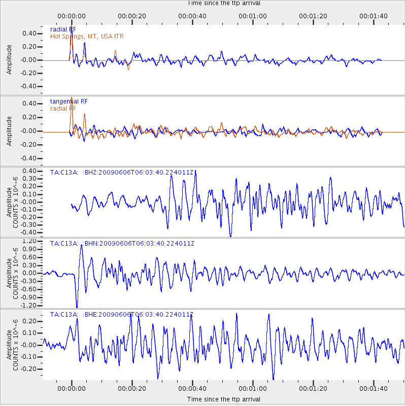
Earthquake location: Near East Coast Of Honshu, Japan
Earthquake latitude/longitude: 35.5/140.9
Earthquake time(UTC): 2009/06/06 (157) 05:52:43 GMT
Earthquake Depth: 34 km
Earthquake Magnitude: 5.8 MB, 5.4 MS, 5.8 MW, 5.7 MW
Earthquake Catalog/Contributor: WHDF/NEIC
Network: TA USArray Transportable Network (new EarthScope stations)
Station: C13A Hot Springs, MT, USA
Lat/Lon: 47.68 N/114.57 W
Elevation: 976 m
Distance: 73.3 deg
Az: 43.085 deg
Baz: 304.413 deg
Ray Param: 0.05306173
Estimated Moho Depth: 35.75 km
Estimated Crust Vp/Vs: 1.78
Assumed Crust Vp: 6.622 km/s
Estimated Crust Vs: 3.72 km/s
Estimated Crust Poisson's Ratio: 0.27
Radial Match: 84.808846 %
Radial Bump: 400
Transverse Match: 73.95649 %
Transverse Bump: 400
SOD ConfigId: 2648
Insert Time: 2010-03-06 08:38:30.018 +0000
GWidth: 2.5
Max Bumps: 400
Tol: 0.001

Signal To Noise

ChannelStoNSTALTA
TA:C13A: :BHN:20090606T06:03:40.224011Z8.7400956.016184E-76.8834304E-8
TA:C13A: :BHE:20090606T06:03:40.224011Z1.44708591.1588567E-78.0082096E-8
TA:C13A: :BHZ:20090606T06:03:40.224011Z2.78353861.8037265E-76.4799764E-8
Arrivals
Ps4.4 SECOND
PpPs14 SECOND
PsPs/PpSs19 SECOND