You are here: Home > Network List > TA - USArray Transportable Network (new EarthScope stations) Stations List
> Station C13A Hot Springs, MT, USA > Earthquake Result Viewer
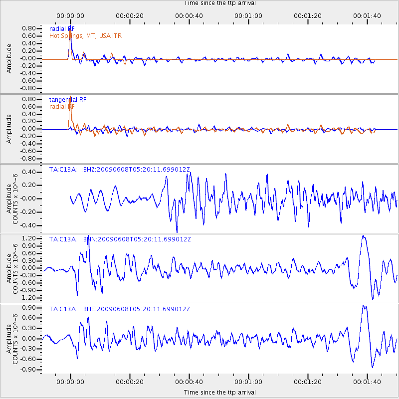
C13A Hot Springs, MT, USA - Earthquake Result Viewer

| Earthquake location: |
Honduras |
| Earthquake latitude/longitude: |
15.8/-86.9 |
| Earthquake time(UTC): |
2009/06/08 (159) 05:13:14 GMT |
| Earthquake Depth: |
10 km |
| Earthquake Magnitude: |
5.5 MB, 4.9 MS, 5.4 MW, 5.4 MW |
| Earthquake Catalog/Contributor: |
WHDF/NEIC |
|
| Network: |
TA USArray Transportable Network (new EarthScope stations) |
| Station: |
C13A Hot Springs, MT, USA |
| Lat/Lon: |
47.68 N/114.57 W |
| Elevation: |
976 m |
|
| Distance: |
39.2 deg |
| Az: |
330.165 deg |
| Baz: |
134.864 deg |
| Ray Param: |
0.07514154 |
| Estimated Moho Depth: |
25.75 km |
| Estimated Crust Vp/Vs: |
2.10 |
| Assumed Crust Vp: |
6.622 km/s |
| Estimated Crust Vs: |
3.157 km/s |
| Estimated Crust Poisson's Ratio: |
0.35 |
|
| Radial Match: |
86.28744 % |
| Radial Bump: |
359 |
| Transverse Match: |
67.922676 % |
| Transverse Bump: |
400 |
| SOD ConfigId: |
2648 |
| Insert Time: |
2010-03-06 08:38:41.383 +0000 |
| GWidth: |
2.5 |
| Max Bumps: |
400 |
| Tol: |
0.001 |
|
Signal To Noise
| Channel | StoN | STA | LTA |
| TA:C13A: :BHN:20090608T05:20:11.699012Z | 6.459744 | 4.309263E-7 | 6.67095E-8 |
| TA:C13A: :BHE:20090608T05:20:11.699012Z | 2.6487665 | 2.8315173E-7 | 1.0689946E-7 |
| TA:C13A: :BHZ:20090608T05:20:11.699012Z | 2.2147782 | 1.8628262E-7 | 8.410893E-8 |
| Arrivals |
| Ps | 4.6 SECOND |
| PpPs | 11 SECOND |
| PsPs/PpSs | 16 SECOND |


