You are here: Home > Network List > TA - USArray Transportable Network (new EarthScope stations) Stations List
> Station C13A Hot Springs, MT, USA > Earthquake Result Viewer
C13A Hot Springs, MT, USA - Earthquake Result Viewer
| Earthquake location: |
Crete, Greece |
| Earthquake latitude/longitude: |
34.2/25.5 |
| Earthquake time(UTC): |
2009/07/01 (182) 09:30:10 GMT |
| Earthquake Depth: |
19 km |
| Earthquake Magnitude: |
6.1 MB, 6.3 MS, 6.4 MW, 6.4 MW |
| Earthquake Catalog/Contributor: |
WHDF/NEIC |
|
| Network: |
TA USArray Transportable Network (new EarthScope stations) |
| Station: |
C13A Hot Springs, MT, USA |
| Lat/Lon: |
47.68 N/114.57 W |
| Elevation: |
976 m |
|
| Distance: |
91.0 deg |
| Az: |
334.277 deg |
| Baz: |
32.18 deg |
| Ray Param: |
0.04163181 |
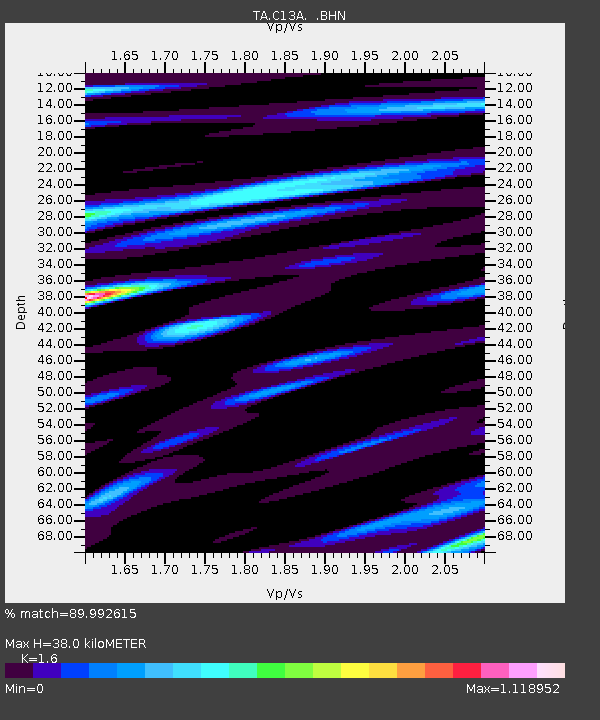
| Estimated Moho Depth: |
38.0 km |
| Estimated Crust Vp/Vs: |
1.60 |
| Assumed Crust Vp: |
6.622 km/s |
| Estimated Crust Vs: |
4.139 km/s |
| Estimated Crust Poisson's Ratio: |
0.18 |
|
| Radial Match: |
89.992615 % |
| Radial Bump: |
400 |
| Transverse Match: |
81.15015 % |
| Transverse Bump: |
400 |
| SOD ConfigId: |
2648 |
| Insert Time: |
2010-03-06 08:38:49.688 +0000 |
| GWidth: |
2.5 |
| Max Bumps: |
400 |
| Tol: |
0.001 |
|
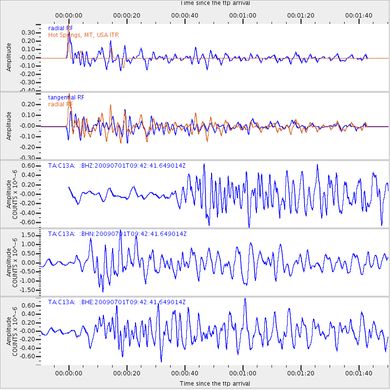
Signal To Noise
| Channel | StoN | STA | LTA |
| TA:C13A: :BHN:20090701T09:42:41.649014Z | 2.2466757 | 2.1291808E-7 | 9.477027E-8 |
| TA:C13A: :BHE:20090701T09:42:41.649014Z | 0.97482836 | 6.569649E-8 | 6.739288E-8 |
| TA:C13A: :BHZ:20090701T09:42:41.649014Z | 0.5531214 | 4.394266E-8 | 7.9444874E-8 |
| Arrivals |
| Ps | 3.5 SECOND |
| PpPs | 15 SECOND |
| PsPs/PpSs | 18 SECOND |


