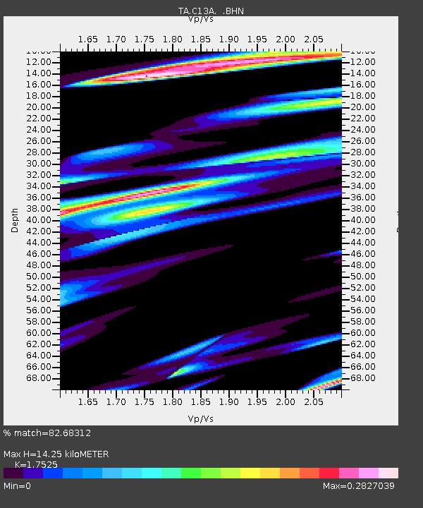
C13A Hot Springs, MT, USA - Earthquake Result Viewer
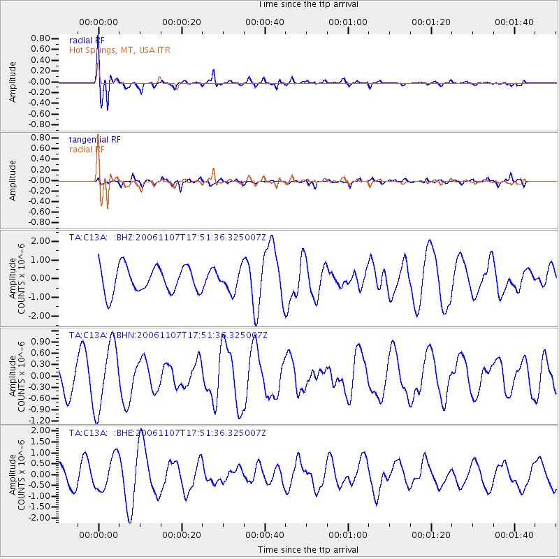
Earthquake location: New Britain Region, P.N.G.
Earthquake latitude/longitude: -6.5/151.2
Earthquake time(UTC): 2006/11/07 (311) 17:38:33 GMT
Earthquake Depth: 10 km
Earthquake Magnitude: 6.2 MB, 6.3 MS, 6.5 MW, 6.4 MW
Earthquake Catalog/Contributor: WHDF/NEIC
Network: TA USArray Transportable Network (new EarthScope stations)
Station: C13A Hot Springs, MT, USA
Lat/Lon: 47.68 N/114.57 W
Elevation: 976 m
Distance: 97.6 deg
Az: 42.834 deg
Baz: 268.744 deg
Ray Param: 0.040166155
Estimated Moho Depth: 14.25 km
Estimated Crust Vp/Vs: 1.75
Assumed Crust Vp: 6.622 km/s
Estimated Crust Vs: 3.779 km/s
Estimated Crust Poisson's Ratio: 0.26
Radial Match: 82.68312 %
Radial Bump: 366
Transverse Match: 49.425697 %
Transverse Bump: 342
SOD ConfigId: 2564
Insert Time: 2010-03-06 08:39:03.103 +0000
GWidth: 2.5
Max Bumps: 400
Tol: 0.001

Signal To Noise

ChannelStoNSTALTA
TA:C13A: :BHN:20061107T17:51:36.325007Z2.75071458.713064E-73.167564E-7
TA:C13A: :BHE:20061107T17:51:36.325007Z1.35412197.903515E-75.8366345E-7
TA:C13A: :BHZ:20061107T17:51:36.325007Z0.85647585.9571624E-76.9554363E-7
Arrivals
Ps1.7 SECOND
PpPs5.8 SECOND
PsPs/PpSs7.5 SECOND