You are here: Home > Network List > TA - USArray Transportable Network (new EarthScope stations) Stations List
> Station C13A Hot Springs, MT, USA > Earthquake Result Viewer
C13A Hot Springs, MT, USA - Earthquake Result Viewer
| Earthquake location: |
Kuril Islands |
| Earthquake latitude/longitude: |
46.3/153.3 |
| Earthquake time(UTC): |
2006/10/13 (286) 13:47:39 GMT |
| Earthquake Depth: |
8.0 km |
| Earthquake Magnitude: |
5.5 MB, 5.8 MS, 6.3 MW, 5.8 MW |
| Earthquake Catalog/Contributor: |
WHDF/NEIC |
|
| Network: |
TA USArray Transportable Network (new EarthScope stations) |
| Station: |
C13A Hot Springs, MT, USA |
| Lat/Lon: |
47.68 N/114.57 W |
| Elevation: |
976 m |
|
| Distance: |
59.1 deg |
| Az: |
51.887 deg |
| Baz: |
306.105 deg |
| Ray Param: |
0.062402215 |
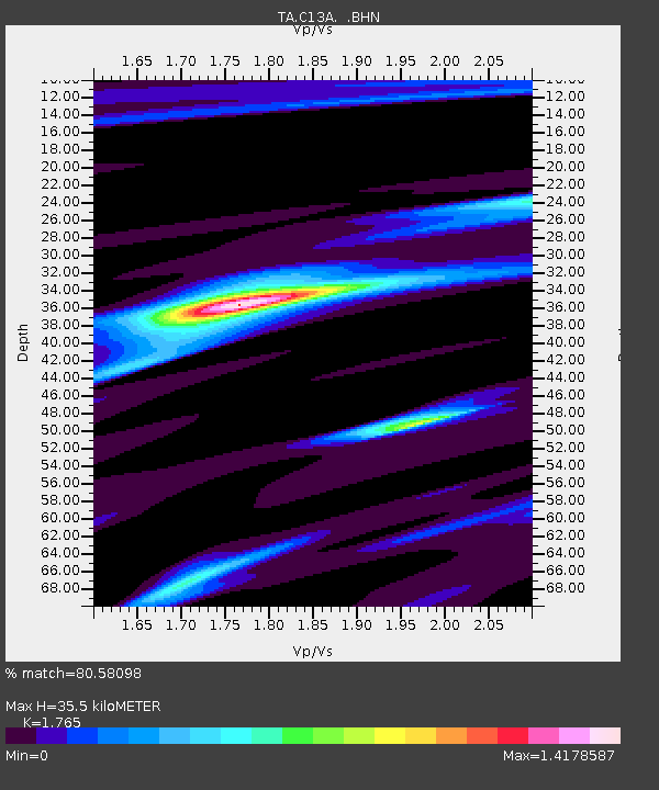
| Estimated Moho Depth: |
35.5 km |
| Estimated Crust Vp/Vs: |
1.76 |
| Assumed Crust Vp: |
6.622 km/s |
| Estimated Crust Vs: |
3.752 km/s |
| Estimated Crust Poisson's Ratio: |
0.26 |
|
| Radial Match: |
80.58098 % |
| Radial Bump: |
258 |
| Transverse Match: |
59.71363 % |
| Transverse Bump: |
396 |
| SOD ConfigId: |
2665 |
| Insert Time: |
2010-03-06 08:39:11.892 +0000 |
| GWidth: |
2.5 |
| Max Bumps: |
400 |
| Tol: |
0.001 |
|
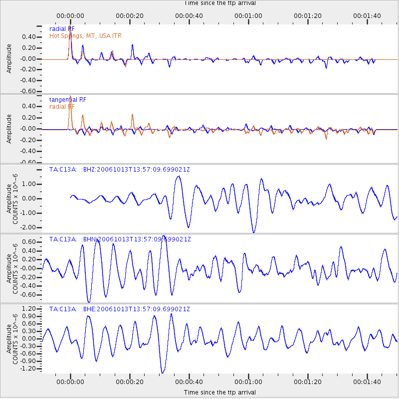
Signal To Noise
| Channel | StoN | STA | LTA |
| TA:C13A: :BHN:20061013T13:57:09.699021Z | 1.9480098 | 2.5482953E-7 | 1.3081532E-7 |
| TA:C13A: :BHE:20061013T13:57:09.699021Z | 1.945887 | 3.6870577E-7 | 1.8947954E-7 |
| TA:C13A: :BHZ:20061013T13:57:09.699021Z | 3.0078301 | 5.949571E-7 | 1.9780276E-7 |
| Arrivals |
| Ps | 4.3 SECOND |
| PpPs | 14 SECOND |
| PsPs/PpSs | 18 SECOND |


