You are here: Home > Network List > TA - USArray Transportable Network (new EarthScope stations) Stations List
> Station D25K Kavik River, AK, USA > Earthquake Result Viewer
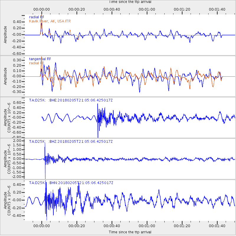
D25K Kavik River, AK, USA - Earthquake Result Viewer
*The percent match for this event was below the threshold and hence no stack was calculated.
| Earthquake location: |
Bonin Islands, Japan Region |
| Earthquake latitude/longitude: |
27.0/140.2 |
| Earthquake time(UTC): |
2018/02/05 (036) 20:56:22 GMT |
| Earthquake Depth: |
465 km |
| Earthquake Magnitude: |
5.3 Mww |
| Earthquake Catalog/Contributor: |
NEIC PDE/us |
|
| Network: |
TA USArray Transportable Network (new EarthScope stations) |
| Station: |
D25K Kavik River, AK, USA |
| Lat/Lon: |
69.32 N/146.38 W |
| Elevation: |
770 m |
|
| Distance: |
59.2 deg |
| Az: |
23.357 deg |
| Baz: |
264.82 deg |
| Ray Param: |
$rayparam |
*The percent match for this event was below the threshold and hence was not used in the summary stack. |
|
| Radial Match: |
53.201157 % |
| Radial Bump: |
400 |
| Transverse Match: |
31.267397 % |
| Transverse Bump: |
400 |
| SOD ConfigId: |
13570011 |
| Insert Time: |
2019-04-29 17:37:21.655 +0000 |
| GWidth: |
2.5 |
| Max Bumps: |
400 |
| Tol: |
0.001 |
|
Signal To Noise
| Channel | StoN | STA | LTA |
| TA:D25K: :BHZ:20180205T21:05:06.425017Z | 6.2679377 | 4.5577224E-7 | 7.271486E-8 |
| TA:D25K: :BHN:20180205T21:05:06.425017Z | 0.94557744 | 1.642755E-7 | 1.7373036E-7 |
| TA:D25K: :BHE:20180205T21:05:06.425017Z | 2.2145793 | 2.0794619E-7 | 9.389873E-8 |
| Arrivals |
| Ps | |
| PpPs | |
| PsPs/PpSs | |


