You are here: Home > Network List > TA - USArray Transportable Network (new EarthScope stations) Stations List
> Station C13A Hot Springs, MT, USA > Earthquake Result Viewer
C13A Hot Springs, MT, USA - Earthquake Result Viewer
| Earthquake location: |
East Of Kuril Islands |
| Earthquake latitude/longitude: |
46.0/154.2 |
| Earthquake time(UTC): |
2007/10/25 (298) 13:50:02 GMT |
| Earthquake Depth: |
10 km |
| Earthquake Magnitude: |
6.0 MB, 5.7 MS, 6.1 MW, 5.9 MW |
| Earthquake Catalog/Contributor: |
WHDF/NEIC |
|
| Network: |
TA USArray Transportable Network (new EarthScope stations) |
| Station: |
C13A Hot Springs, MT, USA |
| Lat/Lon: |
47.68 N/114.57 W |
| Elevation: |
976 m |
|
| Distance: |
58.8 deg |
| Az: |
52.209 deg |
| Baz: |
305.409 deg |
| Ray Param: |
0.062640786 |
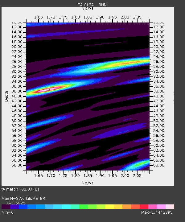
| Estimated Moho Depth: |
37.0 km |
| Estimated Crust Vp/Vs: |
1.69 |
| Assumed Crust Vp: |
6.622 km/s |
| Estimated Crust Vs: |
3.913 km/s |
| Estimated Crust Poisson's Ratio: |
0.23 |
|
| Radial Match: |
80.87701 % |
| Radial Bump: |
396 |
| Transverse Match: |
69.92715 % |
| Transverse Bump: |
386 |
| SOD ConfigId: |
2564 |
| Insert Time: |
2010-03-06 08:39:28.822 +0000 |
| GWidth: |
2.5 |
| Max Bumps: |
400 |
| Tol: |
0.001 |
|
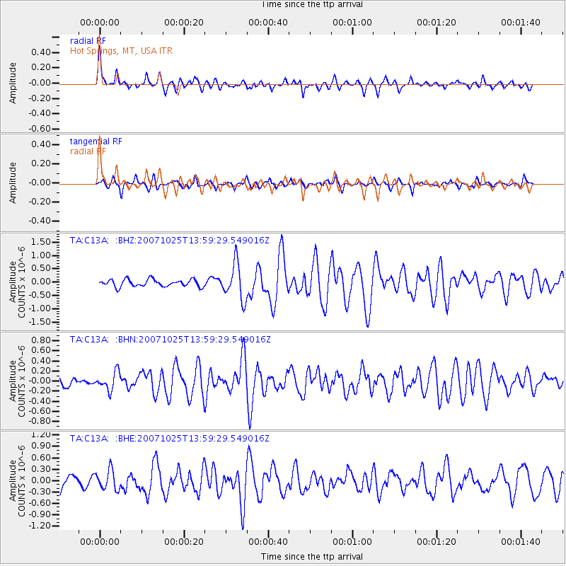
Signal To Noise
| Channel | StoN | STA | LTA |
| TA:C13A: :BHN:20071025T13:59:29.549016Z | 1.5104171 | 1.8187913E-7 | 1.2041649E-7 |
| TA:C13A: :BHE:20071025T13:59:29.549016Z | 1.4703298 | 2.5990295E-7 | 1.7676507E-7 |
| TA:C13A: :BHZ:20071025T13:59:29.549016Z | 5.25265 | 6.9818265E-7 | 1.3292008E-7 |
| Arrivals |
| Ps | 4.1 SECOND |
| PpPs | 14 SECOND |
| PsPs/PpSs | 18 SECOND |


