You are here: Home > Network List > TA - USArray Transportable Network (new EarthScope stations) Stations List
> Station C13A Hot Springs, MT, USA > Earthquake Result Viewer
C13A Hot Springs, MT, USA - Earthquake Result Viewer
| Earthquake location: |
Peru-Brazil Border Region |
| Earthquake latitude/longitude: |
-7.9/-74.4 |
| Earthquake time(UTC): |
2007/07/12 (193) 05:23:49 GMT |
| Earthquake Depth: |
152 km |
| Earthquake Magnitude: |
5.9 MB, 6.1 MW, 6.0 MW |
| Earthquake Catalog/Contributor: |
WHDF/NEIC |
|
| Network: |
TA USArray Transportable Network (new EarthScope stations) |
| Station: |
C13A Hot Springs, MT, USA |
| Lat/Lon: |
47.68 N/114.57 W |
| Elevation: |
976 m |
|
| Distance: |
65.8 deg |
| Az: |
331.432 deg |
| Baz: |
135.494 deg |
| Ray Param: |
0.05761591 |
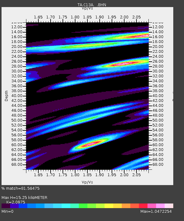
| Estimated Moho Depth: |
15.25 km |
| Estimated Crust Vp/Vs: |
2.10 |
| Assumed Crust Vp: |
6.622 km/s |
| Estimated Crust Vs: |
3.157 km/s |
| Estimated Crust Poisson's Ratio: |
0.35 |
|
| Radial Match: |
81.56475 % |
| Radial Bump: |
400 |
| Transverse Match: |
73.71355 % |
| Transverse Bump: |
400 |
| SOD ConfigId: |
2564 |
| Insert Time: |
2010-03-06 08:40:02.832 +0000 |
| GWidth: |
2.5 |
| Max Bumps: |
400 |
| Tol: |
0.001 |
|
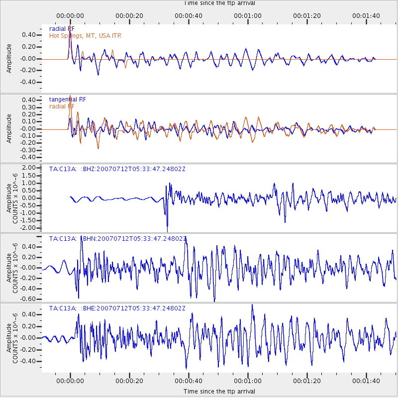
Signal To Noise
| Channel | StoN | STA | LTA |
| TA:C13A: :BHN:20070712T05:33:47.24802Z | 5.148585 | 2.5076906E-7 | 4.8706404E-8 |
| TA:C13A: :BHE:20070712T05:33:47.24802Z | 3.1371582 | 1.8206838E-7 | 5.8036086E-8 |
| TA:C13A: :BHZ:20070712T05:33:47.24802Z | 7.2171354 | 6.240914E-7 | 8.647356E-8 |
| Arrivals |
| Ps | 2.6 SECOND |
| PpPs | 6.9 SECOND |
| PsPs/PpSs | 9.5 SECOND |


