You are here: Home > Network List > TA - USArray Transportable Network (new EarthScope stations) Stations List
> Station C13A Hot Springs, MT, USA > Earthquake Result Viewer
C13A Hot Springs, MT, USA - Earthquake Result Viewer
| Earthquake location: |
Samoa Islands Region |
| Earthquake latitude/longitude: |
-16.4/-172.6 |
| Earthquake time(UTC): |
2007/07/06 (187) 17:40:49 GMT |
| Earthquake Depth: |
10 km |
| Earthquake Magnitude: |
5.5 MB, 5.1 MS, 5.7 MW |
| Earthquake Catalog/Contributor: |
WHDF/NEIC |
|
| Network: |
TA USArray Transportable Network (new EarthScope stations) |
| Station: |
C13A Hot Springs, MT, USA |
| Lat/Lon: |
47.68 N/114.57 W |
| Elevation: |
976 m |
|
| Distance: |
82.2 deg |
| Az: |
35.372 deg |
| Baz: |
235.302 deg |
| Ray Param: |
0.047061026 |
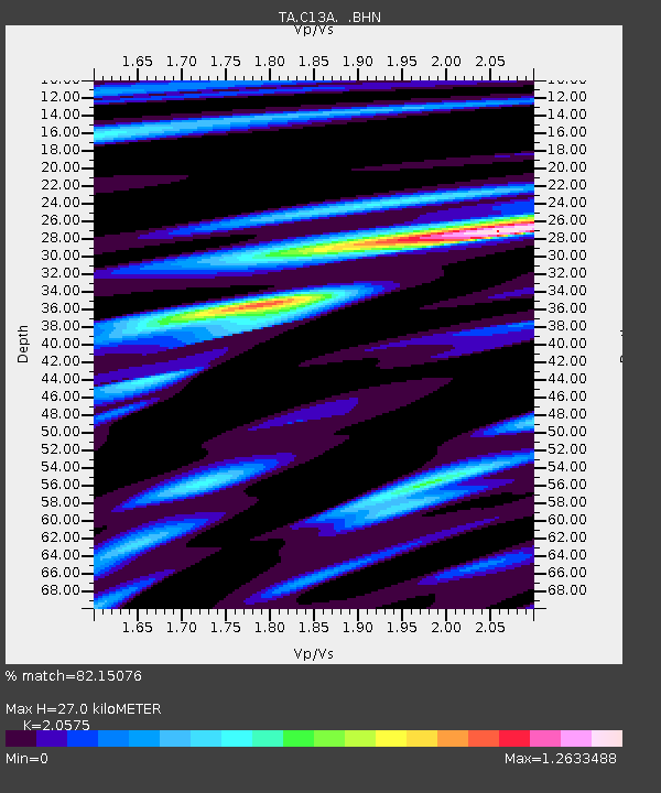
| Estimated Moho Depth: |
27.0 km |
| Estimated Crust Vp/Vs: |
2.06 |
| Assumed Crust Vp: |
6.622 km/s |
| Estimated Crust Vs: |
3.219 km/s |
| Estimated Crust Poisson's Ratio: |
0.35 |
|
| Radial Match: |
82.15076 % |
| Radial Bump: |
400 |
| Transverse Match: |
76.47056 % |
| Transverse Bump: |
400 |
| SOD ConfigId: |
2564 |
| Insert Time: |
2010-03-06 08:40:07.335 +0000 |
| GWidth: |
2.5 |
| Max Bumps: |
400 |
| Tol: |
0.001 |
|
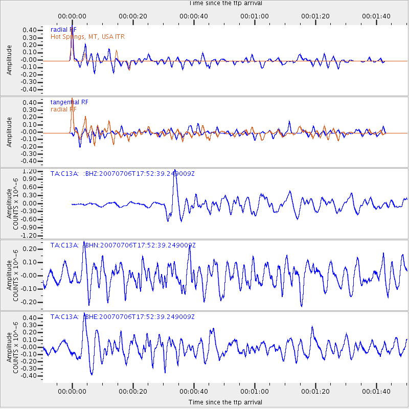
Signal To Noise
| Channel | StoN | STA | LTA |
| TA:C13A: :BHN:20070706T17:52:39.249009Z | 2.1373641 | 1.0241102E-7 | 4.7914632E-8 |
| TA:C13A: :BHE:20070706T17:52:39.249009Z | 4.122504 | 2.018676E-7 | 4.8967227E-8 |
| TA:C13A: :BHZ:20070706T17:52:39.249009Z | 11.213087 | 5.8192876E-7 | 5.189728E-8 |
| Arrivals |
| Ps | 4.4 SECOND |
| PpPs | 12 SECOND |
| PsPs/PpSs | 17 SECOND |


