You are here: Home > Network List > AV - Alaska Volcano Observatory Stations List
> Station AMKA Regional Station, Amchitka Island, Alaska > Earthquake Result Viewer
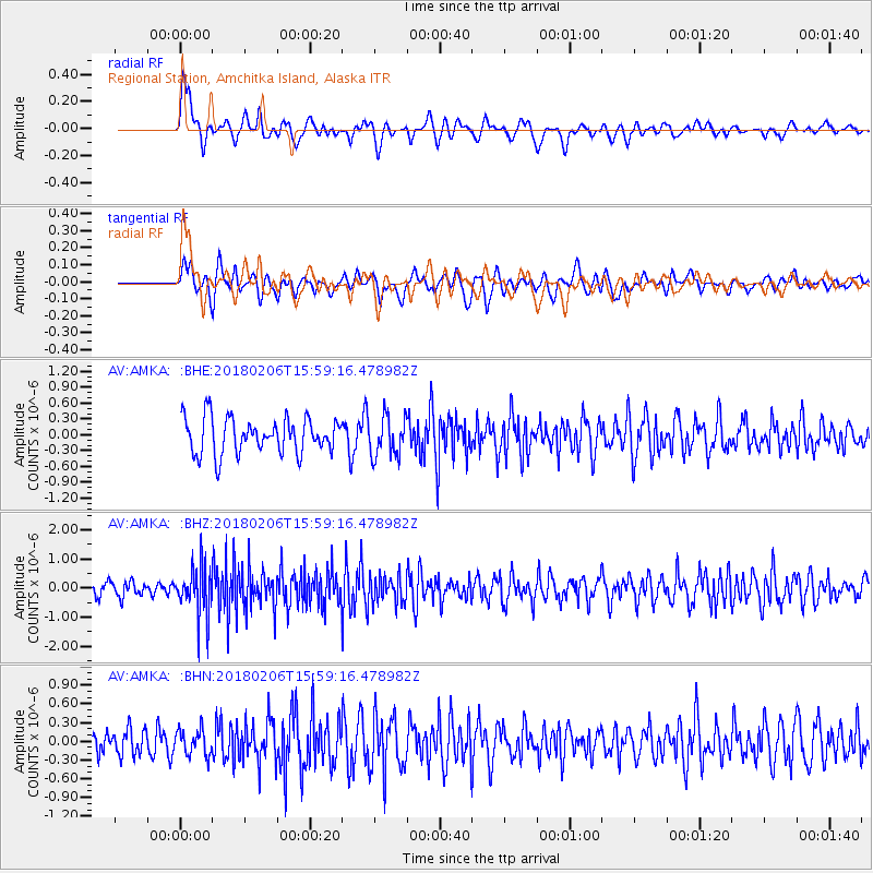
AMKA Regional Station, Amchitka Island, Alaska - Earthquake Result Viewer
*The percent match for this event was below the threshold and hence no stack was calculated.
| Earthquake location: |
Taiwan |
| Earthquake latitude/longitude: |
24.2/121.7 |
| Earthquake time(UTC): |
2018/02/06 (037) 15:50:41 GMT |
| Earthquake Depth: |
9.5 km |
| Earthquake Magnitude: |
6.4 Mww |
| Earthquake Catalog/Contributor: |
NEIC PDE/us |
|
| Network: |
AV Alaska Volcano Observatory |
| Station: |
AMKA Regional Station, Amchitka Island, Alaska |
| Lat/Lon: |
51.38 N/179.30 E |
| Elevation: |
116 m |
|
| Distance: |
51.4 deg |
| Az: |
42.62 deg |
| Baz: |
260.716 deg |
| Ray Param: |
$rayparam |
*The percent match for this event was below the threshold and hence was not used in the summary stack. |
|
| Radial Match: |
42.403816 % |
| Radial Bump: |
400 |
| Transverse Match: |
51.383274 % |
| Transverse Bump: |
400 |
| SOD ConfigId: |
13570011 |
| Insert Time: |
2019-04-29 17:40:20.776 +0000 |
| GWidth: |
2.5 |
| Max Bumps: |
400 |
| Tol: |
0.001 |
|
Signal To Noise
| Channel | StoN | STA | LTA |
| AV:AMKA: :BHZ:20180206T15:59:16.478982Z | 3.8760855 | 8.5363735E-7 | 2.2023183E-7 |
| AV:AMKA: :BHN:20180206T15:59:16.478982Z | 0.9982086 | 2.009619E-7 | 2.0132256E-7 |
| AV:AMKA: :BHE:20180206T15:59:16.478982Z | 1.1635529 | 3.8596824E-7 | 3.3171526E-7 |
| Arrivals |
| Ps | |
| PpPs | |
| PsPs/PpSs | |


