You are here: Home > Network List > TA - USArray Transportable Network (new EarthScope stations) Stations List
> Station C13A Hot Springs, MT, USA > Earthquake Result Viewer
C13A Hot Springs, MT, USA - Earthquake Result Viewer
| Earthquake location: |
Mariana Islands |
| Earthquake latitude/longitude: |
21.0/144.7 |
| Earthquake time(UTC): |
2007/01/30 (030) 21:37:45 GMT |
| Earthquake Depth: |
30 km |
| Earthquake Magnitude: |
6.3 MB, 6.5 MS, 6.6 MW, 6.5 MW |
| Earthquake Catalog/Contributor: |
WHDF/NEIC |
|
| Network: |
TA USArray Transportable Network (new EarthScope stations) |
| Station: |
C13A Hot Springs, MT, USA |
| Lat/Lon: |
47.68 N/114.57 W |
| Elevation: |
976 m |
|
| Distance: |
81.7 deg |
| Az: |
42.145 deg |
| Baz: |
291.887 deg |
| Ray Param: |
0.047384623 |
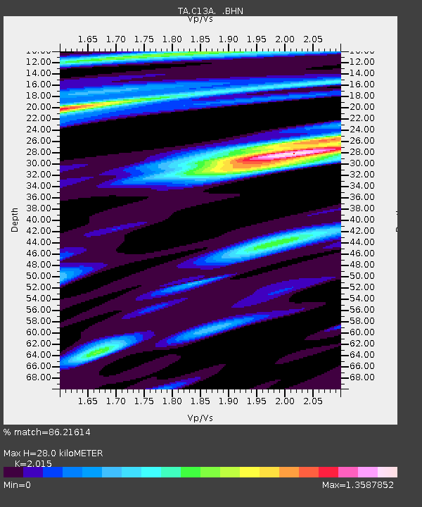
| Estimated Moho Depth: |
28.0 km |
| Estimated Crust Vp/Vs: |
2.02 |
| Assumed Crust Vp: |
6.622 km/s |
| Estimated Crust Vs: |
3.286 km/s |
| Estimated Crust Poisson's Ratio: |
0.34 |
|
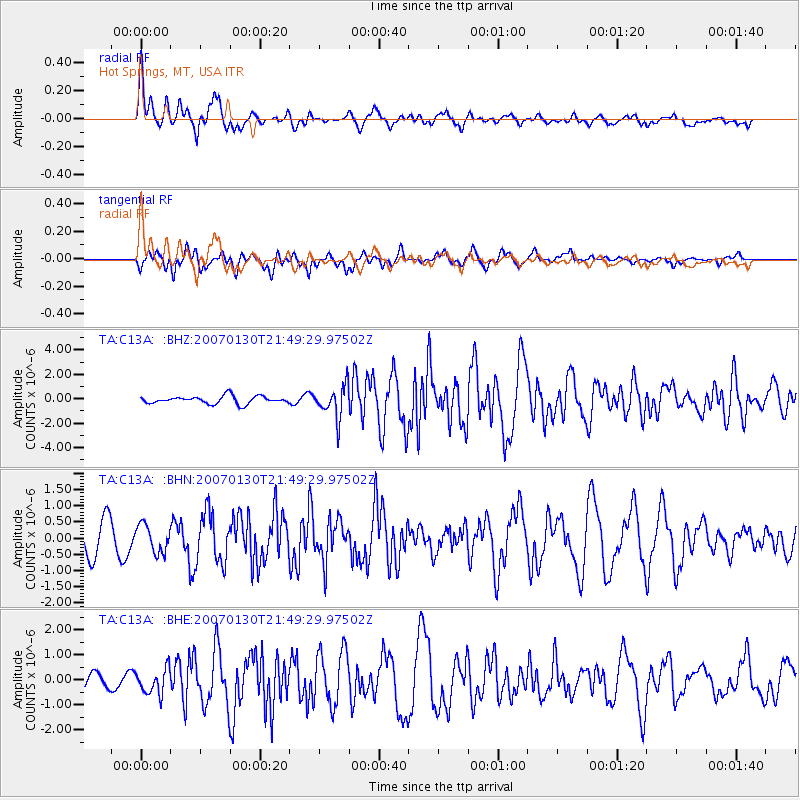
| Radial Match: |
86.21614 % |
| Radial Bump: |
400 |
| Transverse Match: |
74.596634 % |
| Transverse Bump: |
400 |
| SOD ConfigId: |
2564 |
| Insert Time: |
2010-03-06 08:40:21.933 +0000 |
| GWidth: |
2.5 |
| Max Bumps: |
400 |
| Tol: |
0.001 |
|
Signal To Noise
| Channel | StoN | STA | LTA |
| TA:C13A: :BHN:20070130T21:49:29.97502Z | 1.0259302 | 4.2537044E-7 | 4.146193E-7 |
| TA:C13A: :BHE:20070130T21:49:29.97502Z | 1.7291596 | 5.0273485E-7 | 2.9073942E-7 |
| TA:C13A: :BHZ:20070130T21:49:29.97502Z | 4.20526 | 1.3048324E-6 | 3.102858E-7 |
| Arrivals |
| Ps | 4.4 SECOND |
| PpPs | 12 SECOND |
| PsPs/PpSs | 17 SECOND |


