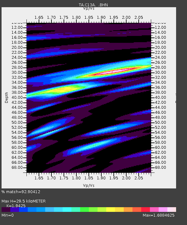
C13A Hot Springs, MT, USA - Earthquake Result Viewer
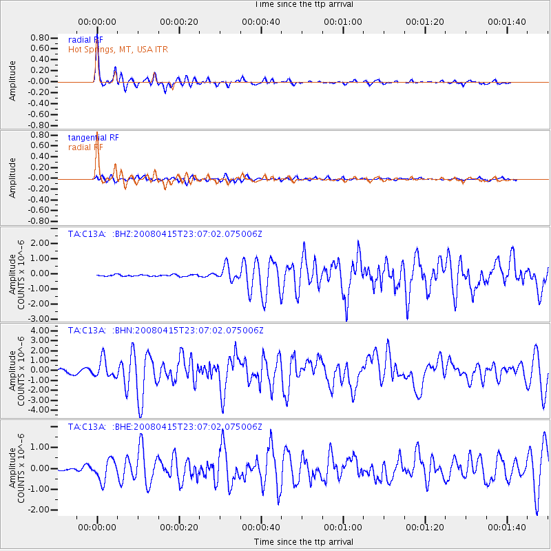
Earthquake location: Andreanof Islands, Aleutian Is.
Earthquake latitude/longitude: 51.9/-179.4
Earthquake time(UTC): 2008/04/15 (106) 22:59:51 GMT
Earthquake Depth: 10 km
Earthquake Magnitude: 6.1 MB, 6.4 MS, 6.4 MW, 6.4 MW
Earthquake Catalog/Contributor: WHDF/NEIC
Network: TA USArray Transportable Network (new EarthScope stations)
Station: C13A Hot Springs, MT, USA
Lat/Lon: 47.68 N/114.57 W
Elevation: 976 m
Distance: 40.8 deg
Az: 69.27 deg
Baz: 300.86 deg
Ray Param: 0.07417545
Estimated Moho Depth: 29.5 km
Estimated Crust Vp/Vs: 1.94
Assumed Crust Vp: 6.622 km/s
Estimated Crust Vs: 3.409 km/s
Estimated Crust Poisson's Ratio: 0.32
Radial Match: 92.90412 %
Radial Bump: 322
Transverse Match: 70.19131 %
Transverse Bump: 400
SOD ConfigId: 2504
Insert Time: 2010-03-06 08:40:28.672 +0000
GWidth: 2.5
Max Bumps: 400
Tol: 0.001

Signal To Noise

ChannelStoNSTALTA
TA:C13A: :BHN:20080415T23:07:02.075006Z6.28695549.625421E-71.5310147E-7
TA:C13A: :BHE:20080415T23:07:02.075006Z4.53934575.116403E-71.12712335E-7
TA:C13A: :BHZ:20080415T23:07:02.075006Z9.0336844.755754E-75.264468E-8
Arrivals
Ps4.5 SECOND
PpPs12 SECOND
PsPs/PpSs17 SECOND