You are here: Home > Network List > GT - Global Telemetered Seismograph Network (USAF/USGS) Stations List
> Station CPUP Villa Florida, Paraguay > Earthquake Result Viewer
CPUP Villa Florida, Paraguay - Earthquake Result Viewer
| Earthquake location: |
Near Coast Of Ecuador |
| Earthquake latitude/longitude: |
0.6/-80.3 |
| Earthquake time(UTC): |
2016/04/20 (111) 08:33:48 GMT |
| Earthquake Depth: |
16 km |
| Earthquake Magnitude: |
6.1 MO |
| Earthquake Catalog/Contributor: |
NEIC PDE/NEIC ALERT |
|
| Network: |
GT Global Telemetered Seismograph Network (USAF/USGS) |
| Station: |
CPUP Villa Florida, Paraguay |
| Lat/Lon: |
26.33 S/57.33 W |
| Elevation: |
105 m |
|
| Distance: |
34.7 deg |
| Az: |
142.142 deg |
| Baz: |
316.858 deg |
| Ray Param: |
0.07757748 |
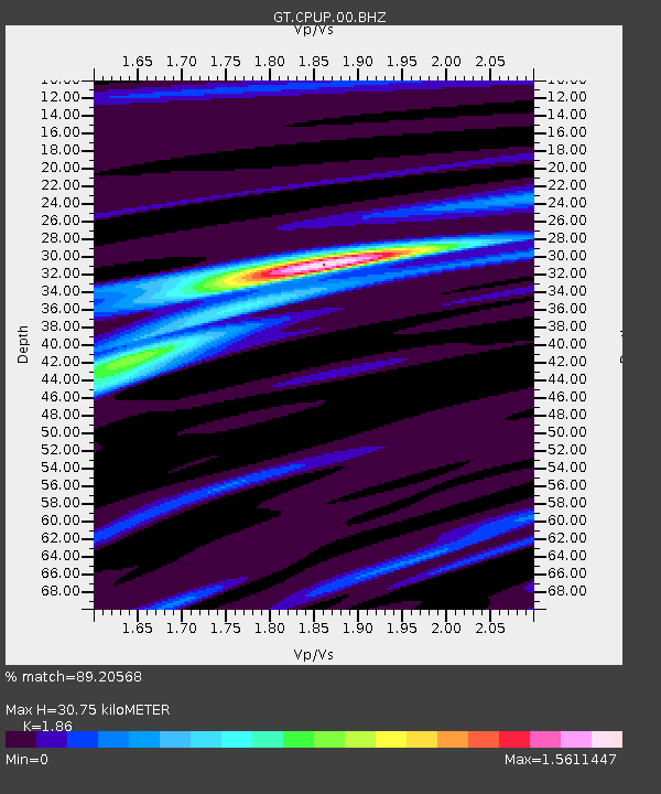
| Estimated Moho Depth: |
30.75 km |
| Estimated Crust Vp/Vs: |
1.86 |
| Assumed Crust Vp: |
6.498 km/s |
| Estimated Crust Vs: |
3.493 km/s |
| Estimated Crust Poisson's Ratio: |
0.30 |
|
| Radial Match: |
89.20568 % |
| Radial Bump: |
255 |
| Transverse Match: |
63.122498 % |
| Transverse Bump: |
400 |
| SOD ConfigId: |
1475611 |
| Insert Time: |
2016-05-04 08:40:50.419 +0000 |
| GWidth: |
2.5 |
| Max Bumps: |
400 |
| Tol: |
0.001 |
|
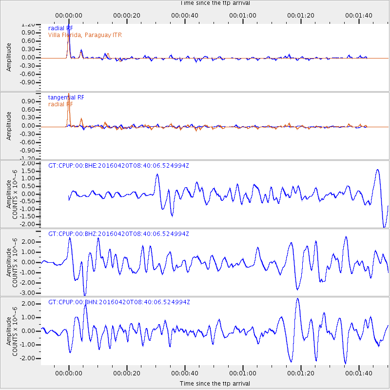
Signal To Noise
| Channel | StoN | STA | LTA |
| GT:CPUP:00:BHZ:20160420T08:40:06.524994Z | 7.076556 | 1.3404056E-6 | 1.8941495E-7 |
| GT:CPUP:00:BHN:20160420T08:40:06.524994Z | 3.925173 | 8.59776E-7 | 2.1904155E-7 |
| GT:CPUP:00:BHE:20160420T08:40:06.524994Z | 5.3624525 | 7.236777E-7 | 1.3495274E-7 |
| Arrivals |
| Ps | 4.4 SECOND |
| PpPs | 13 SECOND |
| PsPs/PpSs | 17 SECOND |


