You are here: Home > Network List > TA - USArray Transportable Network (new EarthScope stations) Stations List
> Station C16K Lisburne Hills, AK, USA > Earthquake Result Viewer
C16K Lisburne Hills, AK, USA - Earthquake Result Viewer
| Earthquake location: |
Taiwan |
| Earthquake latitude/longitude: |
24.2/121.7 |
| Earthquake time(UTC): |
2018/02/06 (037) 15:50:41 GMT |
| Earthquake Depth: |
9.5 km |
| Earthquake Magnitude: |
6.4 Mww |
| Earthquake Catalog/Contributor: |
NEIC PDE/us |
|
| Network: |
TA USArray Transportable Network (new EarthScope stations) |
| Station: |
C16K Lisburne Hills, AK, USA |
| Lat/Lon: |
68.27 N/165.34 W |
| Elevation: |
102 m |
|
| Distance: |
61.5 deg |
| Az: |
23.898 deg |
| Baz: |
263.684 deg |
| Ray Param: |
0.060839657 |
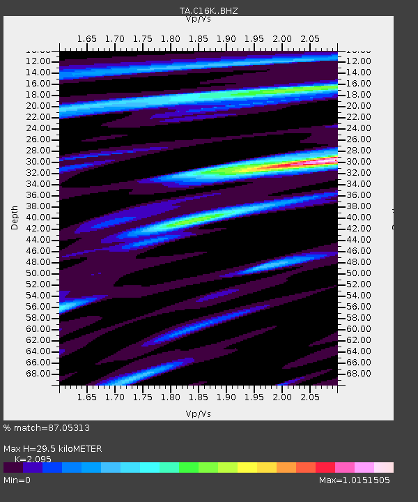
| Estimated Moho Depth: |
29.5 km |
| Estimated Crust Vp/Vs: |
2.10 |
| Assumed Crust Vp: |
5.906 km/s |
| Estimated Crust Vs: |
2.819 km/s |
| Estimated Crust Poisson's Ratio: |
0.35 |
|
| Radial Match: |
87.05313 % |
| Radial Bump: |
400 |
| Transverse Match: |
68.2697 % |
| Transverse Bump: |
400 |
| SOD ConfigId: |
13570011 |
| Insert Time: |
2019-04-29 17:43:16.771 +0000 |
| GWidth: |
2.5 |
| Max Bumps: |
400 |
| Tol: |
0.001 |
|
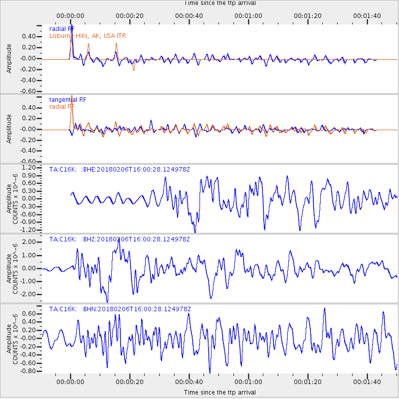
Signal To Noise
| Channel | StoN | STA | LTA |
| TA:C16K: :BHZ:20180206T16:00:28.124978Z | 4.820423 | 6.286452E-7 | 1.3041286E-7 |
| TA:C16K: :BHN:20180206T16:00:28.124978Z | 1.5726831 | 1.909245E-7 | 1.2140049E-7 |
| TA:C16K: :BHE:20180206T16:00:28.124978Z | 3.0122585 | 3.5045474E-7 | 1.1634285E-7 |
| Arrivals |
| Ps | 5.6 SECOND |
| PpPs | 15 SECOND |
| PsPs/PpSs | 21 SECOND |


