You are here: Home > Network List > TA - USArray Transportable Network (new EarthScope stations) Stations List
> Station C18K Utukok River, AK, USA > Earthquake Result Viewer
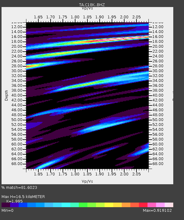
C18K Utukok River, AK, USA - Earthquake Result Viewer
| Earthquake location: |
Taiwan |
| Earthquake latitude/longitude: |
24.2/121.7 |
| Earthquake time(UTC): |
2018/02/06 (037) 15:50:41 GMT |
| Earthquake Depth: |
9.5 km |
| Earthquake Magnitude: |
6.4 Mww |
| Earthquake Catalog/Contributor: |
NEIC PDE/us |
|
| Network: |
TA USArray Transportable Network (new EarthScope stations) |
| Station: |
C18K Utukok River, AK, USA |
| Lat/Lon: |
68.65 N/161.19 W |
| Elevation: |
845 m |
|
| Distance: |
63.0 deg |
| Az: |
23.61 deg |
| Baz: |
267.406 deg |
| Ray Param: |
0.05983003 |
| Estimated Moho Depth: |
16.5 km |
| Estimated Crust Vp/Vs: |
2.00 |
| Assumed Crust Vp: |
5.906 km/s |
| Estimated Crust Vs: |
2.961 km/s |
| Estimated Crust Poisson's Ratio: |
0.33 |
|
| Radial Match: |
81.6023 % |
| Radial Bump: |
400 |
| Transverse Match: |
71.83896 % |
| Transverse Bump: |
400 |
| SOD ConfigId: |
13570011 |
| Insert Time: |
2019-04-29 17:43:19.754 +0000 |
| GWidth: |
2.5 |
| Max Bumps: |
400 |
| Tol: |
0.001 |
|

Signal To Noise
| Channel | StoN | STA | LTA |
| TA:C18K: :BHZ:20180206T16:00:38.525002Z | 4.361492 | 6.059814E-7 | 1.3893901E-7 |
| TA:C18K: :BHN:20180206T16:00:38.525002Z | 1.2416629 | 1.6349705E-7 | 1.3167588E-7 |
| TA:C18K: :BHE:20180206T16:00:38.525002Z | 1.4396806 | 1.9968466E-7 | 1.3870067E-7 |
| Arrivals |
| Ps | 2.9 SECOND |
| PpPs | 8.1 SECOND |
| PsPs/PpSs | 11 SECOND |


