You are here: Home > Network List > TA - USArray Transportable Network (new EarthScope stations) Stations List
> Station F15K North Star Ditch, AK, USA > Earthquake Result Viewer
F15K North Star Ditch, AK, USA - Earthquake Result Viewer
| Earthquake location: |
Taiwan |
| Earthquake latitude/longitude: |
24.2/121.7 |
| Earthquake time(UTC): |
2018/02/06 (037) 15:50:41 GMT |
| Earthquake Depth: |
9.5 km |
| Earthquake Magnitude: |
6.4 Mww |
| Earthquake Catalog/Contributor: |
NEIC PDE/us |
|
| Network: |
TA USArray Transportable Network (new EarthScope stations) |
| Station: |
F15K North Star Ditch, AK, USA |
| Lat/Lon: |
65.71 N/164.65 W |
| Elevation: |
388 m |
|
| Distance: |
61.5 deg |
| Az: |
26.849 deg |
| Baz: |
265.731 deg |
| Ray Param: |
0.06081792 |
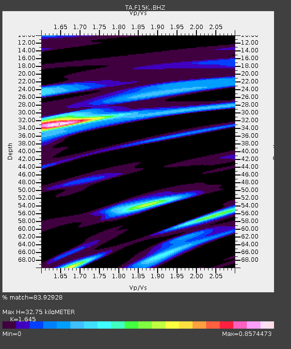
| Estimated Moho Depth: |
32.75 km |
| Estimated Crust Vp/Vs: |
1.64 |
| Assumed Crust Vp: |
6.276 km/s |
| Estimated Crust Vs: |
3.815 km/s |
| Estimated Crust Poisson's Ratio: |
0.21 |
|
| Radial Match: |
83.92928 % |
| Radial Bump: |
400 |
| Transverse Match: |
65.960205 % |
| Transverse Bump: |
400 |
| SOD ConfigId: |
13570011 |
| Insert Time: |
2019-04-29 17:43:37.611 +0000 |
| GWidth: |
2.5 |
| Max Bumps: |
400 |
| Tol: |
0.001 |
|

Signal To Noise
| Channel | StoN | STA | LTA |
| TA:F15K: :BHZ:20180206T16:00:28.350015Z | 6.7187347 | 7.45761E-7 | 1.1099724E-7 |
| TA:F15K: :BHN:20180206T16:00:28.350015Z | 0.87532246 | 1.5709874E-7 | 1.7947526E-7 |
| TA:F15K: :BHE:20180206T16:00:28.350015Z | 2.541402 | 3.2672273E-7 | 1.2856003E-7 |
| Arrivals |
| Ps | 3.5 SECOND |
| PpPs | 13 SECOND |
| PsPs/PpSs | 17 SECOND |


