You are here: Home > Network List > TA - USArray Transportable Network (new EarthScope stations) Stations List
> Station F20K Avaraart Lake, AK, USA > Earthquake Result Viewer
F20K Avaraart Lake, AK, USA - Earthquake Result Viewer
| Earthquake location: |
Taiwan |
| Earthquake latitude/longitude: |
24.2/121.7 |
| Earthquake time(UTC): |
2018/02/06 (037) 15:50:41 GMT |
| Earthquake Depth: |
9.5 km |
| Earthquake Magnitude: |
6.4 Mww |
| Earthquake Catalog/Contributor: |
NEIC PDE/us |
|
| Network: |
TA USArray Transportable Network (new EarthScope stations) |
| Station: |
F20K Avaraart Lake, AK, USA |
| Lat/Lon: |
67.05 N/155.73 W |
| Elevation: |
136 m |
|
| Distance: |
65.1 deg |
| Az: |
25.382 deg |
| Baz: |
273.242 deg |
| Ray Param: |
0.058474142 |
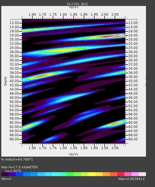
| Estimated Moho Depth: |
17.5 km |
| Estimated Crust Vp/Vs: |
2.10 |
| Assumed Crust Vp: |
6.522 km/s |
| Estimated Crust Vs: |
3.109 km/s |
| Estimated Crust Poisson's Ratio: |
0.35 |
|
| Radial Match: |
84.76971 % |
| Radial Bump: |
400 |
| Transverse Match: |
64.23551 % |
| Transverse Bump: |
400 |
| SOD ConfigId: |
13570011 |
| Insert Time: |
2019-04-29 17:43:39.444 +0000 |
| GWidth: |
2.5 |
| Max Bumps: |
400 |
| Tol: |
0.001 |
|
Signal To Noise
| Channel | StoN | STA | LTA |
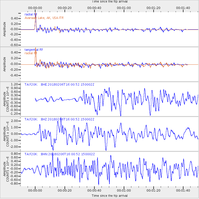
| TA:F20K: :BHZ:20180206T16:00:52.150002Z | 4.9804463 | 5.952859E-7 | 1.195246E-7 |
| TA:F20K: :BHN:20180206T16:00:52.150002Z | 1.0597082 | 1.680023E-7 | 1.5853637E-7 |
| TA:F20K: :BHE:20180206T16:00:52.150002Z | 3.2301924 | 2.942869E-7 | 9.110507E-8 |
| Arrivals |
| Ps | 3.1 SECOND |
| PpPs | 8.0 SECOND |
| PsPs/PpSs | 11 SECOND |


