You are here: Home > Network List > TA - USArray Transportable Network (new EarthScope stations) Stations List
> Station G23K Bananza Creek, AK, USA > Earthquake Result Viewer
G23K Bananza Creek, AK, USA - Earthquake Result Viewer
| Earthquake location: |
Taiwan |
| Earthquake latitude/longitude: |
24.2/121.7 |
| Earthquake time(UTC): |
2018/02/06 (037) 15:50:41 GMT |
| Earthquake Depth: |
9.5 km |
| Earthquake Magnitude: |
6.4 Mww |
| Earthquake Catalog/Contributor: |
NEIC PDE/us |
|
| Network: |
TA USArray Transportable Network (new EarthScope stations) |
| Station: |
G23K Bananza Creek, AK, USA |
| Lat/Lon: |
66.71 N/150.02 W |
| Elevation: |
746 m |
|
| Distance: |
67.4 deg |
| Az: |
25.498 deg |
| Baz: |
278.527 deg |
| Ray Param: |
0.056978866 |
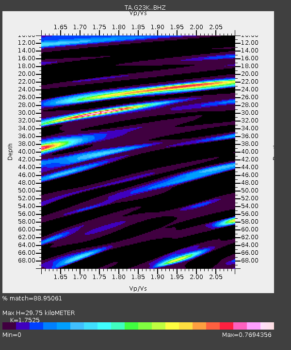
| Estimated Moho Depth: |
29.75 km |
| Estimated Crust Vp/Vs: |
1.75 |
| Assumed Crust Vp: |
6.577 km/s |
| Estimated Crust Vs: |
3.753 km/s |
| Estimated Crust Poisson's Ratio: |
0.26 |
|
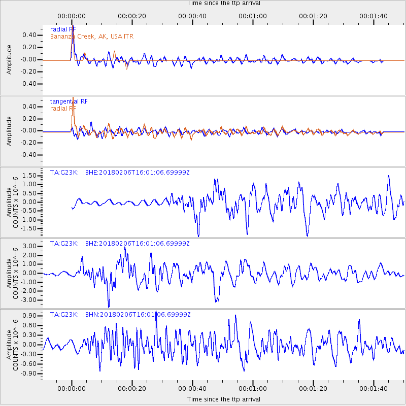
| Radial Match: |
88.95061 % |
| Radial Bump: |
400 |
| Transverse Match: |
75.2652 % |
| Transverse Bump: |
400 |
| SOD ConfigId: |
13570011 |
| Insert Time: |
2019-04-29 17:43:52.102 +0000 |
| GWidth: |
2.5 |
| Max Bumps: |
400 |
| Tol: |
0.001 |
|
Signal To Noise
| Channel | StoN | STA | LTA |
| TA:G23K: :BHZ:20180206T16:01:06.69999Z | 2.8795104 | 6.3863735E-7 | 2.2178678E-7 |
| TA:G23K: :BHN:20180206T16:01:06.69999Z | 1.1186899 | 1.5045072E-7 | 1.3448832E-7 |
| TA:G23K: :BHE:20180206T16:01:06.69999Z | 1.6946114 | 1.9320903E-7 | 1.1401377E-7 |
| Arrivals |
| Ps | 3.6 SECOND |
| PpPs | 12 SECOND |
| PsPs/PpSs | 15 SECOND |


