You are here: Home > Network List > TA - USArray Transportable Network (new EarthScope stations) Stations List
> Station H16K Elim, AK, USA > Earthquake Result Viewer
H16K Elim, AK, USA - Earthquake Result Viewer
| Earthquake location: |
Taiwan |
| Earthquake latitude/longitude: |
24.2/121.7 |
| Earthquake time(UTC): |
2018/02/06 (037) 15:50:41 GMT |
| Earthquake Depth: |
9.5 km |
| Earthquake Magnitude: |
6.4 Mww |
| Earthquake Catalog/Contributor: |
NEIC PDE/us |
|
| Network: |
TA USArray Transportable Network (new EarthScope stations) |
| Station: |
H16K Elim, AK, USA |
| Lat/Lon: |
64.64 N/162.24 W |
| Elevation: |
216 m |
|
| Distance: |
62.5 deg |
| Az: |
28.122 deg |
| Baz: |
268.513 deg |
| Ray Param: |
0.060193658 |
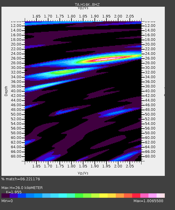
| Estimated Moho Depth: |
26.0 km |
| Estimated Crust Vp/Vs: |
1.96 |
| Assumed Crust Vp: |
6.276 km/s |
| Estimated Crust Vs: |
3.21 km/s |
| Estimated Crust Poisson's Ratio: |
0.32 |
|
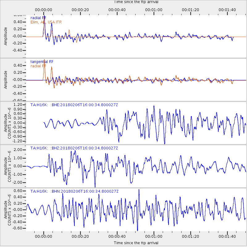
| Radial Match: |
86.221176 % |
| Radial Bump: |
400 |
| Transverse Match: |
61.138565 % |
| Transverse Bump: |
400 |
| SOD ConfigId: |
13570011 |
| Insert Time: |
2019-04-29 17:43:54.656 +0000 |
| GWidth: |
2.5 |
| Max Bumps: |
400 |
| Tol: |
0.001 |
|
Signal To Noise
| Channel | StoN | STA | LTA |
| TA:H16K: :BHZ:20180206T16:00:34.800027Z | 6.7280226 | 5.8599085E-7 | 8.709704E-8 |
| TA:H16K: :BHN:20180206T16:00:34.800027Z | 1.3552788 | 1.5116748E-7 | 1.1153977E-7 |
| TA:H16K: :BHE:20180206T16:00:34.800027Z | 2.2883081 | 3.4648363E-7 | 1.5141477E-7 |
| Arrivals |
| Ps | 4.1 SECOND |
| PpPs | 12 SECOND |
| PsPs/PpSs | 16 SECOND |


