You are here: Home > Network List > TA - USArray Transportable Network (new EarthScope stations) Stations List
> Station I17K Unalakleet, AK, USA > Earthquake Result Viewer
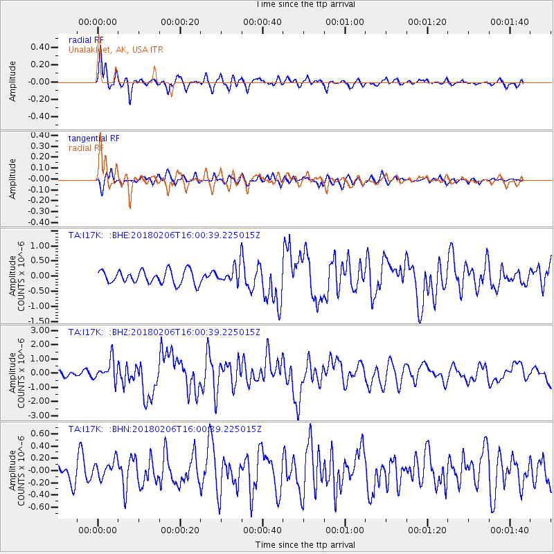
I17K Unalakleet, AK, USA - Earthquake Result Viewer
*The percent match for this event was below the threshold and hence no stack was calculated.
| Earthquake location: |
Taiwan |
| Earthquake latitude/longitude: |
24.2/121.7 |
| Earthquake time(UTC): |
2018/02/06 (037) 15:50:41 GMT |
| Earthquake Depth: |
9.5 km |
| Earthquake Magnitude: |
6.4 Mww |
| Earthquake Catalog/Contributor: |
NEIC PDE/us |
|
| Network: |
TA USArray Transportable Network (new EarthScope stations) |
| Station: |
I17K Unalakleet, AK, USA |
| Lat/Lon: |
63.89 N/160.70 W |
| Elevation: |
105 m |
|
| Distance: |
63.2 deg |
| Az: |
28.978 deg |
| Baz: |
270.293 deg |
| Ray Param: |
$rayparam |
*The percent match for this event was below the threshold and hence was not used in the summary stack. |
|
| Radial Match: |
76.85528 % |
| Radial Bump: |
400 |
| Transverse Match: |
60.84729 % |
| Transverse Bump: |
400 |
| SOD ConfigId: |
13570011 |
| Insert Time: |
2019-04-29 17:44:03.564 +0000 |
| GWidth: |
2.5 |
| Max Bumps: |
400 |
| Tol: |
0.001 |
|
Signal To Noise
| Channel | StoN | STA | LTA |
| TA:I17K: :BHZ:20180206T16:00:39.225015Z | 2.8197656 | 7.505801E-7 | 2.6618528E-7 |
| TA:I17K: :BHN:20180206T16:00:39.225015Z | 0.98901355 | 1.629752E-7 | 1.6478562E-7 |
| TA:I17K: :BHE:20180206T16:00:39.225015Z | 0.98593116 | 2.1473421E-7 | 2.1779839E-7 |
| Arrivals |
| Ps | |
| PpPs | |
| PsPs/PpSs | |


