You are here: Home > Network List > TA - USArray Transportable Network (new EarthScope stations) Stations List
> Station M16K Timber Creek, AK, USA > Earthquake Result Viewer
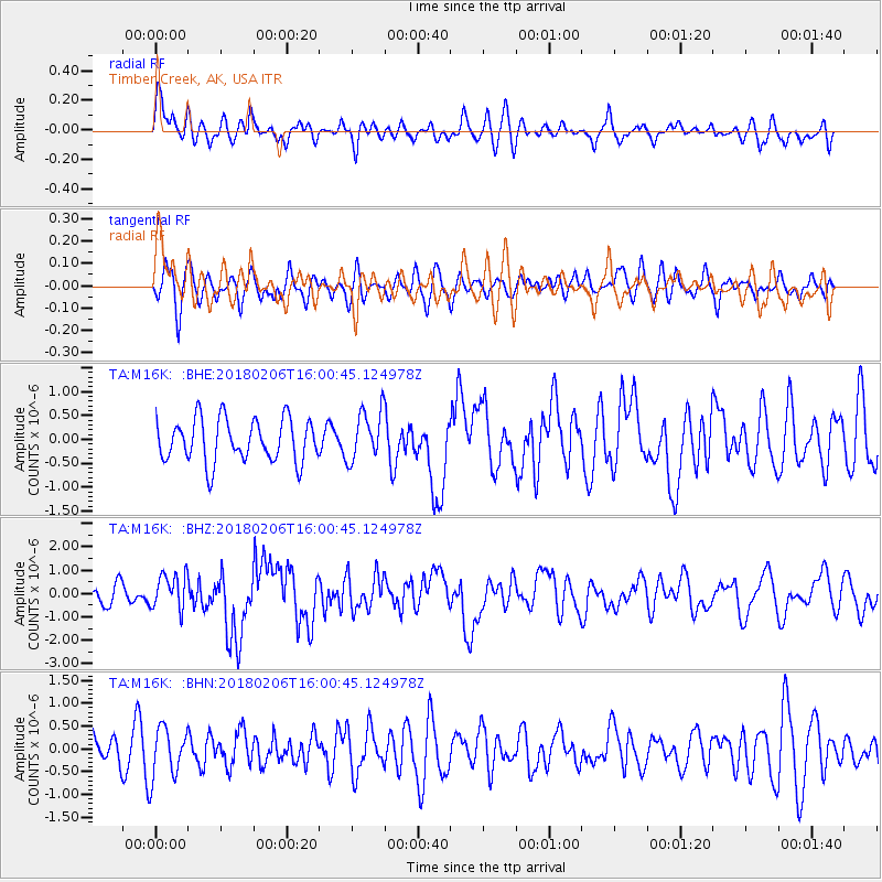
M16K Timber Creek, AK, USA - Earthquake Result Viewer
*The percent match for this event was below the threshold and hence no stack was calculated.
| Earthquake location: |
Taiwan |
| Earthquake latitude/longitude: |
24.2/121.7 |
| Earthquake time(UTC): |
2018/02/06 (037) 15:50:41 GMT |
| Earthquake Depth: |
9.5 km |
| Earthquake Magnitude: |
6.4 Mww |
| Earthquake Catalog/Contributor: |
NEIC PDE/us |
|
| Network: |
TA USArray Transportable Network (new EarthScope stations) |
| Station: |
M16K Timber Creek, AK, USA |
| Lat/Lon: |
61.02 N/158.96 W |
| Elevation: |
394 m |
|
| Distance: |
64.1 deg |
| Az: |
32.158 deg |
| Baz: |
273.244 deg |
| Ray Param: |
$rayparam |
*The percent match for this event was below the threshold and hence was not used in the summary stack. |
|
| Radial Match: |
61.47793 % |
| Radial Bump: |
400 |
| Transverse Match: |
50.97384 % |
| Transverse Bump: |
400 |
| SOD ConfigId: |
13570011 |
| Insert Time: |
2019-04-29 17:44:24.473 +0000 |
| GWidth: |
2.5 |
| Max Bumps: |
400 |
| Tol: |
0.001 |
|
Signal To Noise
| Channel | StoN | STA | LTA |
| TA:M16K: :BHZ:20180206T16:00:45.124978Z | 1.635696 | 7.602347E-7 | 4.647775E-7 |
| TA:M16K: :BHN:20180206T16:00:45.124978Z | 1.9432932 | 5.423068E-7 | 2.7906586E-7 |
| TA:M16K: :BHE:20180206T16:00:45.124978Z | 1.0631435 | 4.78319E-7 | 4.499101E-7 |
| Arrivals |
| Ps | |
| PpPs | |
| PsPs/PpSs | |


