You are here: Home > Network List > TA - USArray Transportable Network (new EarthScope stations) Stations List
> Station C13A Hot Springs, MT, USA > Earthquake Result Viewer
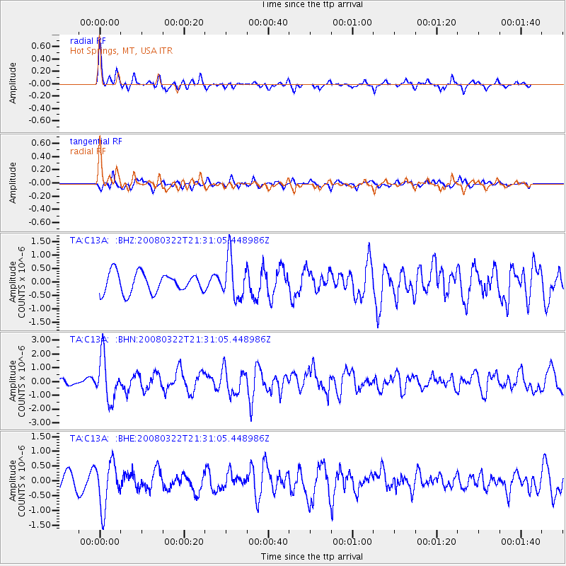
C13A Hot Springs, MT, USA - Earthquake Result Viewer
*The percent match for this event was below the threshold and hence no stack was calculated.
| Earthquake location: |
Andreanof Islands, Aleutian Is. |
| Earthquake latitude/longitude: |
52.2/-178.7 |
| Earthquake time(UTC): |
2008/03/22 (082) 21:24:11 GMT |
| Earthquake Depth: |
132 km |
| Earthquake Magnitude: |
5.8 MB, 6.2 MW, 6.1 MW |
| Earthquake Catalog/Contributor: |
WHDF/NEIC |
|
| Network: |
TA USArray Transportable Network (new EarthScope stations) |
| Station: |
C13A Hot Springs, MT, USA |
| Lat/Lon: |
47.68 N/114.57 W |
| Elevation: |
976 m |
|
| Distance: |
40.3 deg |
| Az: |
69.967 deg |
| Baz: |
301.112 deg |
| Ray Param: |
$rayparam |
*The percent match for this event was below the threshold and hence was not used in the summary stack. |
|
| Radial Match: |
79.04337 % |
| Radial Bump: |
352 |
| Transverse Match: |
46.62913 % |
| Transverse Bump: |
382 |
| SOD ConfigId: |
2504 |
| Insert Time: |
2010-03-06 08:41:15.143 +0000 |
| GWidth: |
2.5 |
| Max Bumps: |
400 |
| Tol: |
0.001 |
|
Signal To Noise
| Channel | StoN | STA | LTA |
| TA:C13A: :BHN:20080322T21:31:05.448986Z | 4.3329687 | 1.584874E-6 | 3.6577094E-7 |
| TA:C13A: :BHE:20080322T21:31:05.448986Z | 1.9271058 | 7.768262E-7 | 4.0310513E-7 |
| TA:C13A: :BHZ:20080322T21:31:05.448986Z | 2.1314232 | 7.8292857E-7 | 3.6732666E-7 |
| Arrivals |
| Ps | |
| PpPs | |
| PsPs/PpSs | |


