You are here: Home > Network List > TA - USArray Transportable Network (new EarthScope stations) Stations List
> Station P17K Kvichak River, AK, USA > Earthquake Result Viewer
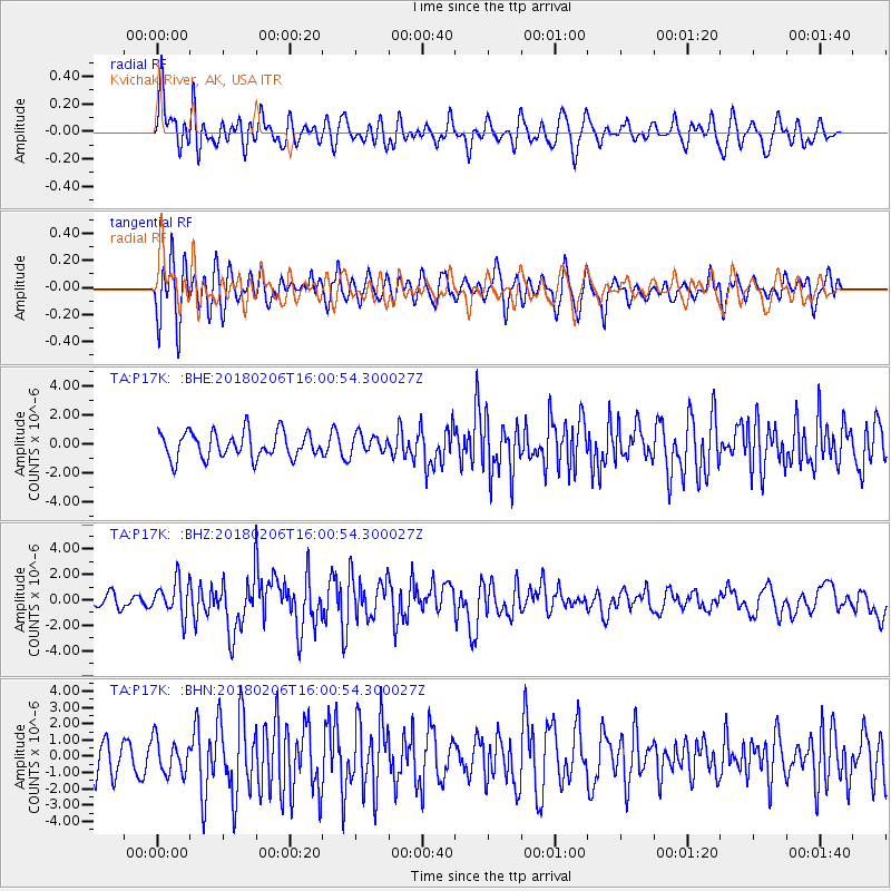
P17K Kvichak River, AK, USA - Earthquake Result Viewer
*The percent match for this event was below the threshold and hence no stack was calculated.
| Earthquake location: |
Taiwan |
| Earthquake latitude/longitude: |
24.2/121.7 |
| Earthquake time(UTC): |
2018/02/06 (037) 15:50:41 GMT |
| Earthquake Depth: |
9.5 km |
| Earthquake Magnitude: |
6.4 Mww |
| Earthquake Catalog/Contributor: |
NEIC PDE/us |
|
| Network: |
TA USArray Transportable Network (new EarthScope stations) |
| Station: |
P17K Kvichak River, AK, USA |
| Lat/Lon: |
59.20 N/156.44 W |
| Elevation: |
91 m |
|
| Distance: |
65.5 deg |
| Az: |
34.062 deg |
| Baz: |
276.238 deg |
| Ray Param: |
$rayparam |
*The percent match for this event was below the threshold and hence was not used in the summary stack. |
|
| Radial Match: |
71.47888 % |
| Radial Bump: |
400 |
| Transverse Match: |
59.670166 % |
| Transverse Bump: |
400 |
| SOD ConfigId: |
13570011 |
| Insert Time: |
2019-04-29 17:44:35.271 +0000 |
| GWidth: |
2.5 |
| Max Bumps: |
400 |
| Tol: |
0.001 |
|
Signal To Noise
| Channel | StoN | STA | LTA |
| TA:P17K: :BHZ:20180206T16:00:54.300027Z | 1.9186178 | 1.3782338E-6 | 7.183473E-7 |
| TA:P17K: :BHN:20180206T16:00:54.300027Z | 0.7790838 | 1.0478974E-6 | 1.3450381E-6 |
| TA:P17K: :BHE:20180206T16:00:54.300027Z | 0.7823063 | 7.078838E-7 | 9.048678E-7 |
| Arrivals |
| Ps | |
| PpPs | |
| PsPs/PpSs | |


