You are here: Home > Network List > TA - USArray Transportable Network (new EarthScope stations) Stations List
> Station C13A Hot Springs, MT, USA > Earthquake Result Viewer
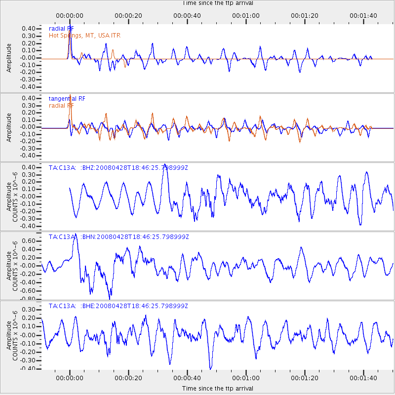
C13A Hot Springs, MT, USA - Earthquake Result Viewer
*The percent match for this event was below the threshold and hence no stack was calculated.
| Earthquake location: |
Vanuatu Islands |
| Earthquake latitude/longitude: |
-19.9/169.0 |
| Earthquake time(UTC): |
2008/04/28 (119) 18:33:34 GMT |
| Earthquake Depth: |
32 km |
| Earthquake Magnitude: |
6.2 MB, 6.2 MS, 6.4 MW, 6.4 MW |
| Earthquake Catalog/Contributor: |
WHDF/NEIC |
|
| Network: |
TA USArray Transportable Network (new EarthScope stations) |
| Station: |
C13A Hot Springs, MT, USA |
| Lat/Lon: |
47.68 N/114.57 W |
| Elevation: |
976 m |
|
| Distance: |
95.8 deg |
| Az: |
41.33 deg |
| Baz: |
246.839 deg |
| Ray Param: |
$rayparam |
*The percent match for this event was below the threshold and hence was not used in the summary stack. |
|
| Radial Match: |
63.201942 % |
| Radial Bump: |
346 |
| Transverse Match: |
41.12148 % |
| Transverse Bump: |
400 |
| SOD ConfigId: |
2504 |
| Insert Time: |
2010-03-06 08:41:21.819 +0000 |
| GWidth: |
2.5 |
| Max Bumps: |
400 |
| Tol: |
0.001 |
|
Signal To Noise
| Channel | StoN | STA | LTA |
| TA:C13A: :BHN:20080428T18:46:25.798999Z | 3.5226388 | 4.280889E-7 | 1.2152506E-7 |
| TA:C13A: :BHE:20080428T18:46:25.798999Z | 1.3202287 | 1.3378366E-7 | 1.013337E-7 |
| TA:C13A: :BHZ:20080428T18:46:25.798999Z | 2.0662816 | 2.560361E-7 | 1.2391153E-7 |
| Arrivals |
| Ps | |
| PpPs | |
| PsPs/PpSs | |


