You are here: Home > Network List > UW - Pacific Northwest Regional Seismic Network Stations List
> Station UMAT Pilot Rock, OR, USA > Earthquake Result Viewer
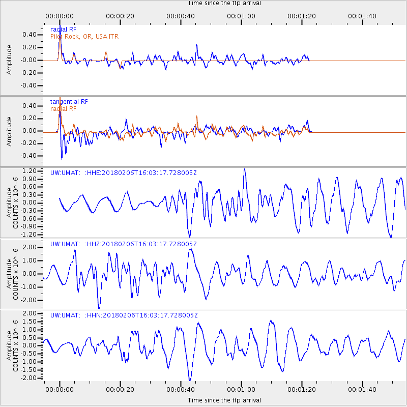
UMAT Pilot Rock, OR, USA - Earthquake Result Viewer
*The percent match for this event was below the threshold and hence no stack was calculated.
| Earthquake location: |
Taiwan |
| Earthquake latitude/longitude: |
24.2/121.7 |
| Earthquake time(UTC): |
2018/02/06 (037) 15:50:41 GMT |
| Earthquake Depth: |
9.5 km |
| Earthquake Magnitude: |
6.4 Mww |
| Earthquake Catalog/Contributor: |
NEIC PDE/us |
|
| Network: |
UW Pacific Northwest Regional Seismic Network |
| Station: |
UMAT Pilot Rock, OR, USA |
| Lat/Lon: |
45.29 N/118.96 W |
| Elevation: |
1318 m |
|
| Distance: |
91.6 deg |
| Az: |
37.986 deg |
| Baz: |
307.21 deg |
| Ray Param: |
$rayparam |
*The percent match for this event was below the threshold and hence was not used in the summary stack. |
|
| Radial Match: |
67.015434 % |
| Radial Bump: |
316 |
| Transverse Match: |
51.1411 % |
| Transverse Bump: |
400 |
| SOD ConfigId: |
13570011 |
| Insert Time: |
2019-04-29 17:45:05.224 +0000 |
| GWidth: |
2.5 |
| Max Bumps: |
400 |
| Tol: |
0.001 |
|
Signal To Noise
| Channel | StoN | STA | LTA |
| UW:UMAT: :HHZ:20180206T16:03:17.728005Z | 3.2429698 | 6.911797E-7 | 2.1313171E-7 |
| UW:UMAT: :HHN:20180206T16:03:17.728005Z | 0.6922661 | 1.9304196E-7 | 2.7885514E-7 |
| UW:UMAT: :HHE:20180206T16:03:17.728005Z | 0.4104995 | 8.726649E-8 | 2.125861E-7 |
| Arrivals |
| Ps | |
| PpPs | |
| PsPs/PpSs | |


